IMAGES TAKEN NEAR TO
Water Lane, NEWPORT PAGNELL, MK16 9NR
Introduction
This page details the photographs taken nearby to Water Lane, MK16 9NR by members of the Geograph project.
The Geograph project started in 2005 with the aim of publishing, organising and preserving representative images for every square kilometre of Great Britain, Ireland and the Isle of Man.

There are currently over 7.5m images from over14,400 individuals and you can help contribute to the project by visiting https://www.geograph.org.uk
Image Map
Images are licensed for reuse under creativecommons.org/licenses/by-sa/2.0
Notes
- Clicking on the map will re-center to the selected point.
- The higher the marker number, the further away the image location is from the centre of the postcode.
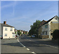
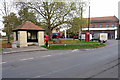
Image Listing (20 Images Found)
Images are licensed for reuse under creativecommons.org/licenses/by-sa/2.0
Image
Details
Distance
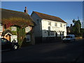
2
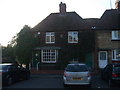
Sherington Road - Sherington
Looking north with the Sun Inn on right hand side. See http://www.sherington.org.uk/
Image: © John Winfield
Taken: 1 Jul 2006
0.09 miles
10
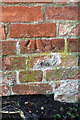
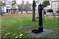
Benchmark on Crofts End wall
Ordnance Survey cut mark benchmark described on the Bench Mark Database at http://www.bench-marks.org.uk/bm46446
Image: © Roger Templeman
Taken: 23 Nov 2016
0.19 miles