IMAGES TAKEN NEAR TO
Lewenscroft, NEWPORT PAGNELL, MK16 9JN
Introduction
This page details the photographs taken nearby to Lewenscroft, MK16 9JN by members of the Geograph project.
The Geograph project started in 2005 with the aim of publishing, organising and preserving representative images for every square kilometre of Great Britain, Ireland and the Isle of Man.

There are currently over 7.5m images from over14,400 individuals and you can help contribute to the project by visiting https://www.geograph.org.uk
Image Map (Loading...)


Getting Data...Please wait
Leaflet Map data © OpenStreetMap
Images are licensed for reuse under creativecommons.org/licenses/by-sa/2.0
Notes
- Clicking on the map will re-center to the selected point.
- The higher the marker number, the further away the image location is from the centre of the postcode.
Image Listing (20 Images Found)
Images are licensed for reuse under creativecommons.org/licenses/by-sa/2.0
Image
Details
Distance

3
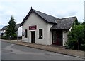
Main Road, Astwood
No longer a 'main road', as the village is now bypassed by the A422. The building on the right is the Astwood Village Hall.
Image: © M J Richardson
Taken: 18 Nov 2015
0.13 miles
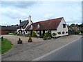
4

The Old Swan pub, Astwood
See previous photo from June http://www.geograph.org.uk/photo/3534381. This time in February on a sunny day with much harsher light.
Image: © Bikeboy
Taken: 16 Feb 2014
0.14 miles
5
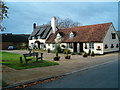
The Old Swan
The Old Swan, Astwood.
Image: © Richard Schmidt
Taken: 11 Nov 2006
0.14 miles

8

Astwood, St. Peter's Churchyard: Comma butterfly 'Polygonia c-album on a gravestone
Image: © Michael Garlick
Taken: 25 Jul 2023
0.19 miles
9
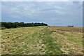
Milton Keynes Boundary Walk heading for Dollar's Grove
Image: © Philip Jeffrey
Taken: 7 Sep 2024
0.19 miles