IMAGES TAKEN NEAR TO
East End, NEWPORT PAGNELL, MK16 9HW
Introduction
This page details the photographs taken nearby to East End, MK16 9HW by members of the Geograph project.
The Geograph project started in 2005 with the aim of publishing, organising and preserving representative images for every square kilometre of Great Britain, Ireland and the Isle of Man.

There are currently over 7.5m images from over14,400 individuals and you can help contribute to the project by visiting https://www.geograph.org.uk
Image Map
Images are licensed for reuse under creativecommons.org/licenses/by-sa/2.0
Notes
- Clicking on the map will re-center to the selected point.
- The higher the marker number, the further away the image location is from the centre of the postcode.
Image Listing (3 Images Found)
Images are licensed for reuse under creativecommons.org/licenses/by-sa/2.0
Image
Details
Distance
1
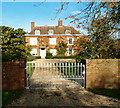
East End
An impressive house in East End.
Image: © Richard Schmidt
Taken: 5 Nov 2006
0.16 miles
2
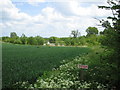
Fishing lake Quaker's Farm
From wheat field on Milton Keynes Boundary Walk footpath near East End.
Image: © ian saunders
Taken: 20 May 2007
0.17 miles
3
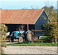
Old Tractor
An old tractor sat in the farmyard at the end of the road at East End.
Image: © Richard Schmidt
Taken: 5 Nov 2006
0.22 miles