IMAGES TAKEN NEAR TO
Spring Mews, NEWPORT PAGNELL, MK16 9FT
Introduction
This page details the photographs taken nearby to Spring Mews, MK16 9FT by members of the Geograph project.
The Geograph project started in 2005 with the aim of publishing, organising and preserving representative images for every square kilometre of Great Britain, Ireland and the Isle of Man.

There are currently over 7.5m images from over14,400 individuals and you can help contribute to the project by visiting https://www.geograph.org.uk
Image Map
Images are licensed for reuse under creativecommons.org/licenses/by-sa/2.0
Notes
- Clicking on the map will re-center to the selected point.
- The higher the marker number, the further away the image location is from the centre of the postcode.
Image Listing (16 Images Found)
Images are licensed for reuse under creativecommons.org/licenses/by-sa/2.0
Image
Details
Distance
2
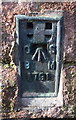
Benchmark on Winnowing Barn
Ordnance Survey flush bracket (serial number 1791) benchmark described on the Bench Mark Database at http://www.bench-marks.org.uk/bm1211
Image: © Roger Templeman
Taken: 23 Nov 2016
0.11 miles
3
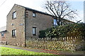
Winnowing Barn, High Street
There is an OS flush bracket benchmark Image on the near corner of the building where the stone wall abuts
Image: © Roger Templeman
Taken: 23 Nov 2016
0.11 miles
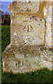
4

Ordnance Survey Flush Bracket 1791
This can be found on the wall of Winnowing Barn.
For more detail see : http://www.bench-marks.org.uk/bm1211
Image: © Peter Wood
Taken: 27 Nov 2012
0.11 miles
5
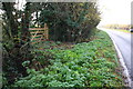
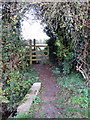
Culvert for ditch beside north end of High Street
Image: © Roger Templeman
Taken: 23 Nov 2016
0.12 miles
8
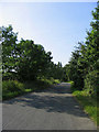
Gun Lane - Sherington
Looking south towards Sherington village
Image: © John Winfield
Taken: 1 Jul 2006
0.22 miles
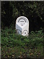
9
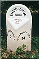
Old Milepost by the former A509, north of Sherington
Pressed steel post by the UC road (was A509), in parish of Sherington (Milton Keynes District), High Street; North of Sherington village, 100m South of junction with Gun Lane, on grass verge between road and ditch with hedge, on East side of road. Bucks pressing, erected by the County Council in the 20th century.
Inscription reads:-
: NEWPORT PAGNELL / 2 : : SHERINGTON / PARISH / LONDON / 52 : : WELLINGBOROUGH / 14 :
Milestone Society National ID: BU_NPWB02
Image: © A Rosevear & J Higgins
Taken: 20 Aug 2003
0.23 miles
10
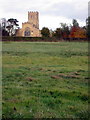
Benchmark on buttress of Laud's Church
Ordnance Survey cut mark benchmark described on the Bench Mark Database at http://www.bench-marks.org.uk/bm80573
Image: © Roger Templeman
Taken: 23 Nov 2016
0.23 miles