IMAGES TAKEN NEAR TO
Thurne Close, NEWPORT PAGNELL, MK16 9DY
Introduction
This page details the photographs taken nearby to Thurne Close, MK16 9DY by members of the Geograph project.
The Geograph project started in 2005 with the aim of publishing, organising and preserving representative images for every square kilometre of Great Britain, Ireland and the Isle of Man.

There are currently over 7.5m images from over14,400 individuals and you can help contribute to the project by visiting https://www.geograph.org.uk
Image Map
Images are licensed for reuse under creativecommons.org/licenses/by-sa/2.0
Notes
- Clicking on the map will re-center to the selected point.
- The higher the marker number, the further away the image location is from the centre of the postcode.
Image Listing (8 Images Found)
Images are licensed for reuse under creativecommons.org/licenses/by-sa/2.0
Image
Details
Distance
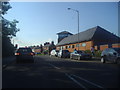
3
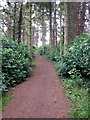
Path towards Newport Pagnell from the Lovat
Image: © Philip Jeffrey
Taken: 18 Jun 2012
0.15 miles
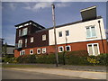
4
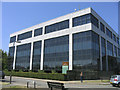
Harben House, Newport Pagnell
Conference and training centre located in Tickford Street
Image: © John Winfield
Taken: 1 Jul 2006
0.16 miles
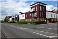
5
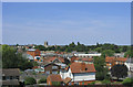
Newport Pagnell skyline
Looking north-west from the 3rd floor of Harben House
Image: © John Winfield
Taken: 1 Jul 2006
0.16 miles