IMAGES TAKEN NEAR TO
Flora Thompson Drive, NEWPORT PAGNELL, MK16 8ST
Introduction
This page details the photographs taken nearby to Flora Thompson Drive, MK16 8ST by members of the Geograph project.
The Geograph project started in 2005 with the aim of publishing, organising and preserving representative images for every square kilometre of Great Britain, Ireland and the Isle of Man.

There are currently over 7.5m images from over14,400 individuals and you can help contribute to the project by visiting https://www.geograph.org.uk
Image Map
Images are licensed for reuse under creativecommons.org/licenses/by-sa/2.0
Notes
- Clicking on the map will re-center to the selected point.
- The higher the marker number, the further away the image location is from the centre of the postcode.
Image Listing (3 Images Found)
Images are licensed for reuse under creativecommons.org/licenses/by-sa/2.0
Image
Details
Distance
1
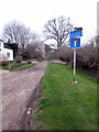
Lakes Lane as it becomes the Ouse Valley Way
Image: © Philip Jeffrey
Taken: 15 Mar 2012
0.16 miles
2
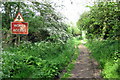
Lakes Lane
It's been a while since this bridleway needed a traffic sign.
Image: © Philip Jeffrey
Taken: 24 May 2012
0.21 miles
3
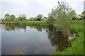
Gravel pit lake by the Ouse Valley Way
Image: © Philip Jeffrey
Taken: 24 May 2012
0.24 miles