IMAGES TAKEN NEAR TO
Mill Street, NEWPORT PAGNELL, MK16 8ER
Introduction
This page details the photographs taken nearby to Mill Street, MK16 8ER by members of the Geograph project.
The Geograph project started in 2005 with the aim of publishing, organising and preserving representative images for every square kilometre of Great Britain, Ireland and the Isle of Man.

There are currently over 7.5m images from over14,400 individuals and you can help contribute to the project by visiting https://www.geograph.org.uk
Image Map
Images are licensed for reuse under creativecommons.org/licenses/by-sa/2.0
Notes
- Clicking on the map will re-center to the selected point.
- The higher the marker number, the further away the image location is from the centre of the postcode.
Image Listing (91 Images Found)
Images are licensed for reuse under creativecommons.org/licenses/by-sa/2.0
Image
Details
Distance
1
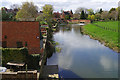
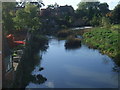
River Great Ouse, Newport Pagnell
One channel of the river passes some of Newport Pagnell's back gardens. This view is seen from North Bridge.
Image: © Stephen McKay
Taken: 23 Apr 2016
0.03 miles
2
River Great Ouse
Taken from North Bridge on the B526
Image: © Geographer
Taken: 18 Oct 2012
0.03 miles
3
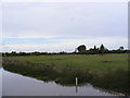
Fields next to the River Great Ouse
Taken from North Bridge
Image: © Geographer
Taken: 18 Oct 2012
0.04 miles
4
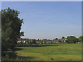
Newport Pagnell from Great Ouse meadows
A view of the north side of Newport Pagnell from the meadows of the Great Ouse River.
Image: © John Winfield
Taken: 1 Jul 2006
0.04 miles
6
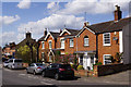
North Square, Newport Pagnell
The area where Union Street and Mill Street meet is known as North Square and is believed to have once been the site of a market. The houses seen here back onto the River Great Ouse.
Image: © Stephen McKay
Taken: 23 Apr 2016
0.06 miles
7
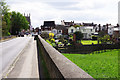
North Bridge, Newport Pagnell
Entering the town on the B526 across North Bridge crossing the River Great Ouse.
Image: © Stephen McKay
Taken: 23 Apr 2016
0.06 miles
8
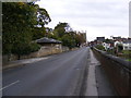
B526 Northampton Road at North Bridge
Looking towards Newport Pagnell
Image: © Geographer
Taken: 18 Oct 2012
0.07 miles
9
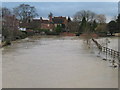
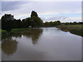
Great Ouse in flood
Looking west from North Bridge.
Image: © Peter Wood
Taken: 27 Nov 2012
0.07 miles
10
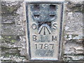
Ordnance Survey Flush Bracket 1787
This can be found on the wall of North Bridge.
For more detail see : http://www.bench-marks.org.uk/bm972
Image: © Peter Wood
Taken: 27 Nov 2012
0.07 miles