IMAGES TAKEN NEAR TO
The Green, NEWPORT PAGNELL, MK16 0JW
Introduction
This page details the photographs taken nearby to The Green, MK16 0JW by members of the Geograph project.
The Geograph project started in 2005 with the aim of publishing, organising and preserving representative images for every square kilometre of Great Britain, Ireland and the Isle of Man.

There are currently over 7.5m images from over14,400 individuals and you can help contribute to the project by visiting https://www.geograph.org.uk
Image Map
Images are licensed for reuse under creativecommons.org/licenses/by-sa/2.0
Notes
- Clicking on the map will re-center to the selected point.
- The higher the marker number, the further away the image location is from the centre of the postcode.
Image Listing (19 Images Found)
Images are licensed for reuse under creativecommons.org/licenses/by-sa/2.0
Image
Details
Distance
1
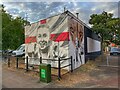
Leah Williamson mural
Painted to celebrate England's win in the Euro 2022 competition
Image: © Philip Jeffrey
Taken: 4 Aug 2022
0.03 miles
2
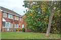
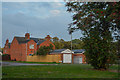
Newport Pagnell : Houses
Houses off of Marsh End Road.
Image: © Lewis Clarke
Taken: 5 Oct 2018
0.07 miles
3
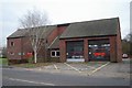
Newport Pagnell fire station
Newport Pagnell fire station, Wolverton Road, Newport Pagnell, Buckinghamshire
Image: © Kevin Hale
Taken: 24 Nov 2007
0.08 miles
4
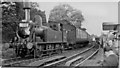
RCTS Rail Tour at Newport Pagnell
View westward, towards Wolverton. Ex-LNW Webb 'Coal Tank' 2F 0-6-2T No. 58887 (designed 1882, withdrawn 4/55) has run round its train from Wolverton. This is part of the RCTS 'Buckinghamshire Rail Tour' - and the fireman is changing the headlamps for the return run. This engine also took us from Cheddington to Aylesbury High Street and back (see Image]) on the complex tour that had started at Blackfriars. The Newport Pagnell branch from Wolverton was closed to passengers on 7/9/64, to goods on 22/5/67.
Image: © Ben Brooksbank
Taken: 10 Oct 1954
0.11 miles
5
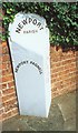
Old Milepost by High Street, Newport Pagnell
Pressed steel post by the UC road, in parish of Newport Pagnell (Milton Keynes District), High Street; at junction with Station Road, outside the Police Museum, in the tarmac pavement, bolted to the boundary wall of the museum, on North side of road. Bucks pressing, erected by the County Council in the 20th century.
Inscription reads:-
: NEWPORT PAGNELL : : NEWPORT / PARISH : : STONY STRATFORD / 6 / BUCKINGHAM / 13¾ :
Grade II listed.
List Entry Number: 1380136 https://historicengland.org.uk/listing/the-list/list-entry/1380136
Milestone Society National ID: BU_BUNP13
Image: © A Rosevear
Taken: 21 Aug 2002
0.12 miles

7
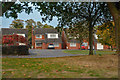
Newport Pagnell : Houses
A grassy area between Marsh End Road and Richmond Way.
Image: © Lewis Clarke
Taken: 5 Oct 2018
0.14 miles
8
Newport Pagnell : Richmond Way
Looking across to Richmond Way from Marsh End Road.
Image: © Lewis Clarke
Taken: 5 Oct 2018
0.16 miles
9

OS Flush Bracket
Newport Pagnell High Street
Image: © Lord Richard Jewell
Taken: 24 Apr 2017
0.17 miles
10
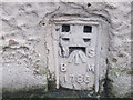
Ordnance Survey Flush Bracket 1786
This can be found on the wall of Church House.
For more detail see : http://www.bench-marks.org.uk/bm971
Image: © Peter Wood
Taken: 27 Nov 2012
0.17 miles