IMAGES TAKEN NEAR TO
Downs Field, NEWPORT PAGNELL, MK16 0HH
Introduction
This page details the photographs taken nearby to Downs Field, MK16 0HH by members of the Geograph project.
The Geograph project started in 2005 with the aim of publishing, organising and preserving representative images for every square kilometre of Great Britain, Ireland and the Isle of Man.

There are currently over 7.5m images from over14,400 individuals and you can help contribute to the project by visiting https://www.geograph.org.uk
Image Map
Images are licensed for reuse under creativecommons.org/licenses/by-sa/2.0
Notes
- Clicking on the map will re-center to the selected point.
- The higher the marker number, the further away the image location is from the centre of the postcode.
Image Listing (12 Images Found)
Images are licensed for reuse under creativecommons.org/licenses/by-sa/2.0
Image
Details
Distance
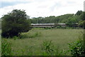
1
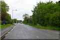
Path towards Newport Pagnell from the Lovat
Image: © Philip Jeffrey
Taken: 18 Jun 2012
0.04 miles
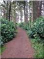
6
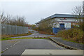
Blocked turning off Renny Park Road
There seem to be alternative ways of access on the industrial estate.
Image: © Robin Webster
Taken: 5 Dec 2021
0.19 miles
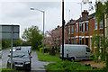
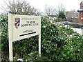
8
North Crawley Road
Looking west at the junction with Howard Way, leading to Interchange Business park.
Image: © M J Richardson
Taken: 18 Nov 2015
0.22 miles
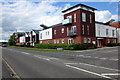
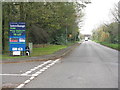
9

Borough of Milton Keynes : London Road B526
A road heading off from Tickford Roundabout.
Image: © Lewis Clarke
Taken: 5 Oct 2018
0.22 miles