IMAGES TAKEN NEAR TO
The Maltings, NEWPORT PAGNELL, MK16 0FH
Introduction
This page details the photographs taken nearby to The Maltings, MK16 0FH by members of the Geograph project.
The Geograph project started in 2005 with the aim of publishing, organising and preserving representative images for every square kilometre of Great Britain, Ireland and the Isle of Man.

There are currently over 7.5m images from over14,400 individuals and you can help contribute to the project by visiting https://www.geograph.org.uk
Image Map
Images are licensed for reuse under creativecommons.org/licenses/by-sa/2.0
Notes
- Clicking on the map will re-center to the selected point.
- The higher the marker number, the further away the image location is from the centre of the postcode.
Image Listing (94 Images Found)
Images are licensed for reuse under creativecommons.org/licenses/by-sa/2.0
Image
Details
Distance
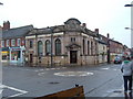
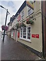
2
Newport Pagnell: the Plough
The lights have come on as darkness falls on the town.
Image: © Chris Downer
Taken: 29 Nov 2010
0.01 miles
3
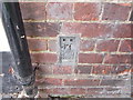
OS Flush Bracket
Plough PH, Newport Pagnell High Street.
Image: © Lord Richard Jewell
Taken: 24 Apr 2017
0.02 miles
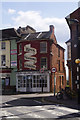
4
The Cannon public house on the High Street
Image: © Adie Jackson
Taken: 6 Oct 2010
0.02 miles
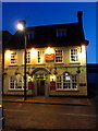
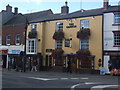
5
The Plough, Newport Pagnell
The Plough in Newport Pagnell, now run by new management
Image: © Ryan Griffiths
Taken: 30 Jul 2021
0.02 miles
6
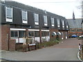
Newport Pagnell Telephone Exchange (2)
This photo shows the North side of this TE in Silver Street with the United Reformed Church in the distance on the right. In the foreground is the entrance to The Maltings, which comprises eight terraced houses. The postcode of this TE is MK16 0EJ.
Image: © David Hillas
Taken: 17 Mar 2012
0.02 miles
7
St John Street, Newport Pagnell
St John Street, seen here from its junction with High street, crosses Tickford Bridge and becomes Tickford Street. Silver Street leads off to the right.
Image: © Stephen McKay
Taken: 23 Apr 2016
0.03 miles
8
Newport Pagnell Telephone Exchange (1)
Situated in Silver Street, this TE replaced the former Manual TE in the early 1970s. Besides Newport Pagnell, this TE also serves Gayhurst, Lathbury, Moulsoe, Sherington, and Tyringham nearby. The BT warning notices can be seen by the gate on the left of the photo whilst the United Reformed Church can just be seen on the extreme left.
Image: © David Hillas
Taken: 17 Mar 2012
0.03 miles
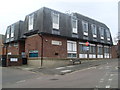
9
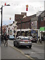
Newport Pagnell, High Street
Looking west.
Image: © Peter Wood
Taken: 27 Nov 2012
0.03 miles
10
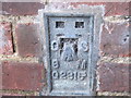
Ordnance Survey Flush Bracket G2315
This can be found on the wall of The Plough PH.
For more detail see : http://www.bench-marks.org.uk/bm705
Image: © Peter Wood
Taken: 27 Nov 2012
0.03 miles