IMAGES TAKEN NEAR TO
Annesley Road, NEWPORT PAGNELL, MK16 0DJ
Introduction
This page details the photographs taken nearby to Annesley Road, MK16 0DJ by members of the Geograph project.
The Geograph project started in 2005 with the aim of publishing, organising and preserving representative images for every square kilometre of Great Britain, Ireland and the Isle of Man.

There are currently over 7.5m images from over14,400 individuals and you can help contribute to the project by visiting https://www.geograph.org.uk
Image Map
Images are licensed for reuse under creativecommons.org/licenses/by-sa/2.0
Notes
- Clicking on the map will re-center to the selected point.
- The higher the marker number, the further away the image location is from the centre of the postcode.
Image Listing (18 Images Found)
Images are licensed for reuse under creativecommons.org/licenses/by-sa/2.0
Image
Details
Distance
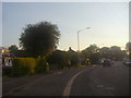
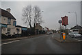
3
Newport Pagnell : Wolverton Road
Looking along Wolverton Road.
Image: © Lewis Clarke
Taken: 5 Oct 2018
0.15 miles
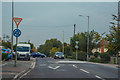
6
Newport Pagnell : Wolverton Road
Looking along Wolverton Road in Newport Pagnell.
Image: © Lewis Clarke
Taken: 24 Mar 2018
0.16 miles
7
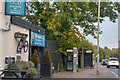
Newport Pagnell : Wolverton Road
Looking along Wolverton Road beside The Red House.
Image: © Lewis Clarke
Taken: 5 Oct 2018
0.16 miles
8
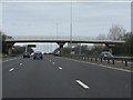
M1 motorway - footbridge near Tanners Drive
Image: © Peter Whatley
Taken: 3 Apr 2012
0.16 miles
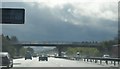
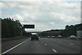
9
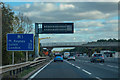
Borough of Milton Keynes : M1 Motorway
The M1 Motorway between Junction 15 (Collingtree) and Junction 14 (Broughton).
Image: © Lewis Clarke
Taken: 3 Oct 2018
0.16 miles
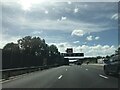
10
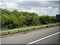
Bushes and mileage sign on M1 southbound near Newport Pagnell
Image: © Colin Pyle
Taken: 9 May 2011
0.16 miles