IMAGES TAKEN NEAR TO
Tuffnell Close, MILTON KEYNES, MK15 9LB
Introduction
This page details the photographs taken nearby to Tuffnell Close, MK15 9LB by members of the Geograph project.
The Geograph project started in 2005 with the aim of publishing, organising and preserving representative images for every square kilometre of Great Britain, Ireland and the Isle of Man.

There are currently over 7.5m images from over14,400 individuals and you can help contribute to the project by visiting https://www.geograph.org.uk
Image Map
Images are licensed for reuse under creativecommons.org/licenses/by-sa/2.0
Notes
- Clicking on the map will re-center to the selected point.
- The higher the marker number, the further away the image location is from the centre of the postcode.
Image Listing (19 Images Found)
Images are licensed for reuse under creativecommons.org/licenses/by-sa/2.0
Image
Details
Distance
1

A Willen local pond
Somewhat fuller than usual
Image: © Philip Jeffrey
Taken: 5 May 2012
0.10 miles
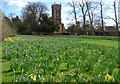
2
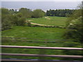
Parkland near Willen seen from the M1 northbound
Image: © Colin Pyle
Taken: 18 May 2012
0.11 miles
3
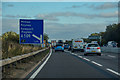
Route confirmatory sign, M1 motorway
This way for "The North" and "The Midlands". About as simple as it gets.
Image: © Peter Whatley
Taken: 3 Apr 2012
0.13 miles
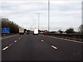
4
M1 at Driver Location A81.4
Passing Driver Location Sign (DLS) at M1 A81.4, near to Milton Keynes.
Driver location signs are now widely used across the motorway and A–road network. First introduced in 2003, they complement distance marker posts. Both types of marker post display the distances in kilometres from a nominal start point but driver location signs are designed to be read by motorists or their passengers when, for instance, they need to pass details to the emergency services. They give the same location information as distance marker posts, but more visibly on larger signs. They are normally spaced at 500-metre intervals along the nearside verge but if obstacles (eg sliproads or bridges) prevent signs from being erected at these locations, then the interval is reduced to either 400 or 300 metres.
Driver location signs have three pieces of information:
• The road identifier (eg M1)
• The carriageway identifier – The letter on the second line of the signs, usually “A” or “B”, tells the emergency services or the Highways Agency in which direction you are travelling. The letter “A” ("Away from London") normally denotes carriageways leaving London (or clockwise in the case of the M25) and "B" ("Back to London") is used for carriageways going to London (anticlockwise on the M25).
• The location (which is identical to the location given on marker posts). Distances are accurate to within 20 metres and are generally quoted from the beginning of the motorway.
So in this case, we are travelling on the M1, away from London, and are 81.4km from the start of the motorway.
http://www.dft.gov.uk/ha/standards/ians/pdfs/ian93r1.pdf DFT Interim Advice Note (December 2010)
http://www.theaa.com/motoring_advice/breakdown_advice/driver-location-signs.html The AA
http://www.sabre-roads.org.uk/wiki/index.php?title=Driver_Location_Signs SABRE
Image: © David Dixon
Taken: 11 Nov 2018
0.14 miles
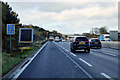
5
Approaching Junction 14
M1 heading south east towards London.
Image: © JThomas
Taken: 5 Mar 2012
0.14 miles
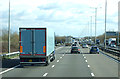
6
Borough of Milton Keynes : M1 Motorway
The M1 Motorway between Junction 15 (Collingtree) and Junction 14 (Broughton).
Image: © Lewis Clarke
Taken: 3 Oct 2018
0.15 miles
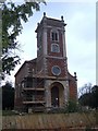
7
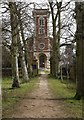
The Pathway to Willen Church
St. Mary Magdalene.
Image: © Cameraman
Taken: 18 Mar 2010
0.17 miles
10
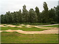
BMX Track
The purpose built BMX Track in Pineham
Image: © Richard Schmidt
Taken: 2 Sep 2006
0.19 miles