IMAGES TAKEN NEAR TO
Portland Drive, MILTON KEYNES, MK15 9JW
Introduction
This page details the photographs taken nearby to Portland Drive, MK15 9JW by members of the Geograph project.
The Geograph project started in 2005 with the aim of publishing, organising and preserving representative images for every square kilometre of Great Britain, Ireland and the Isle of Man.

There are currently over 7.5m images from over14,400 individuals and you can help contribute to the project by visiting https://www.geograph.org.uk
Image Map
Images are licensed for reuse under creativecommons.org/licenses/by-sa/2.0
Notes
- Clicking on the map will re-center to the selected point.
- The higher the marker number, the further away the image location is from the centre of the postcode.
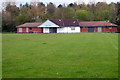
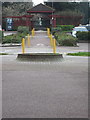
Image Listing (7 Images Found)
Images are licensed for reuse under creativecommons.org/licenses/by-sa/2.0
Image
Details
Distance
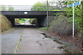
1
Redway to Bolbeck Park through Willen local centre
Image: © Philip Jeffrey
Taken: 29 Apr 2012
0.07 miles

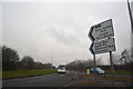
3
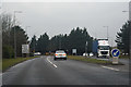
Milton Keynes : Brickhill Street
Looking along Brickhill Street as it approaches the roundabout.
Image: © Lewis Clarke
Taken: 24 Mar 2018
0.14 miles
4
Milton Keynes : Dansteed Way
Looking along Dansteed Way from the roundabout.
Image: © Lewis Clarke
Taken: 24 Mar 2018
0.15 miles
5
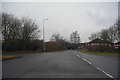
Milton Keynes : Brickhill Street
Looking along Brickhill Street in Milton Keynes.
Image: © Lewis Clarke
Taken: 24 Mar 2018
0.22 miles