IMAGES TAKEN NEAR TO
St. Stephens Drive, MILTON KEYNES, MK15 8QB
Introduction
This page details the photographs taken nearby to St. Stephens Drive, MK15 8QB by members of the Geograph project.
The Geograph project started in 2005 with the aim of publishing, organising and preserving representative images for every square kilometre of Great Britain, Ireland and the Isle of Man.

There are currently over 7.5m images from over14,400 individuals and you can help contribute to the project by visiting https://www.geograph.org.uk
Image Map
Images are licensed for reuse under creativecommons.org/licenses/by-sa/2.0
Notes
- Clicking on the map will re-center to the selected point.
- The higher the marker number, the further away the image location is from the centre of the postcode.
Image Listing (21 Images Found)
Images are licensed for reuse under creativecommons.org/licenses/by-sa/2.0
Image
Details
Distance
1
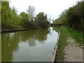
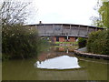
Bridge 80, Grand Junction Canal
Another stretch of the Grand Union that has changed greatly over time. According to old-maps.co.uk, this is the former site of a swing bridge. As Bridge 80 is completely missing now, this is the assumed location. In a strange quirk, the current Bridge 79D is actually further south of this location, meaning the bridges (if 80 was still built) would go 79C, 80, 79D, 80A.
Image: © Mr Biz
Taken: 31 Mar 2012
0.12 miles
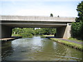
2
Dansteed Way Bridge No 80
Crossing the Grand Union Canal in Milton Keynes.
Image: © Mat Fascione
Taken: 8 Aug 2015
0.12 miles
3
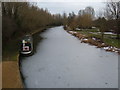
Grand Union Canal
Looking south along the Grand Union Canal from a footbridge connecting Pennyland and Bolbeck Park. You can see that the canal is still frozen, even though the weather had started to warm up a few days before.
Image: © Mr Biz
Taken: 15 Feb 2009
0.12 miles
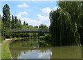
4
Footbridge across the entrance to the Pennyland Boat Basin
An area of private moorings in the Pennyland area of Milton Keynes.
Image: © Mat Fascione
Taken: 8 Aug 2015
0.12 miles
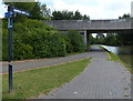
5
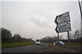
Milton Keynes : Dansteed Way
Looking along Dansteed Way from the roundabout.
Image: © Lewis Clarke
Taken: 24 Mar 2018
0.13 miles
6
Bridge over entrance to Pennyland Boat Basin
Private moorings for homeowners.
Image: © Mr Biz
Taken: 31 Mar 2012
0.14 miles
7
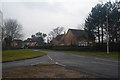
Milton Keynes : Redvers Gate
A road heading off from Brickhill Street.
Image: © Lewis Clarke
Taken: 24 Mar 2018
0.14 miles
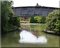
9
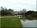
Grand Union Canal: Bridge Number 79D
Bridge Number 79D carries Dansteed Way over the canal. This is H4 in Milton Keynes' road grid system.
Image: © Nigel Cox
Taken: 1 Sep 2013
0.16 miles
10
Footbridge No 79c crossing the Grand Union Canal
Image: © Mat Fascione
Taken: 8 Aug 2015
0.16 miles