IMAGES TAKEN NEAR TO
Sterling Close, MILTON KEYNES, MK15 8AN
Introduction
This page details the photographs taken nearby to Sterling Close, MK15 8AN by members of the Geograph project.
The Geograph project started in 2005 with the aim of publishing, organising and preserving representative images for every square kilometre of Great Britain, Ireland and the Isle of Man.

There are currently over 7.5m images from over14,400 individuals and you can help contribute to the project by visiting https://www.geograph.org.uk
Image Map
Images are licensed for reuse under creativecommons.org/licenses/by-sa/2.0
Notes
- Clicking on the map will re-center to the selected point.
- The higher the marker number, the further away the image location is from the centre of the postcode.
Image Listing (3 Images Found)
Images are licensed for reuse under creativecommons.org/licenses/by-sa/2.0
Image
Details
Distance
1
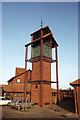
Clock Tower at Neath Hill Shopping Precinct, Milton Keynes
Image: © Colin Park
Taken: 25 Jan 1984
0.12 miles
2
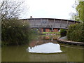
Bridge over entrance to Pennyland Boat Basin
Private moorings for homeowners.
Image: © Mr Biz
Taken: 31 Mar 2012
0.24 miles
3
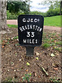
Grand Union Canal between bridges 79a and 79b in Milton Keynes
Between bridges 79a (A422) and 79b (Redwell Bridge)
Braunston 33
Milestone Society National ID: GUC-33
Image: © Dawn Markwell
Taken: 21 Jul 2020
0.25 miles