IMAGES TAKEN NEAR TO
Fennel Drive, MILTON KEYNES, MK14 7EX
Introduction
This page details the photographs taken nearby to Fennel Drive, MK14 7EX by members of the Geograph project.
The Geograph project started in 2005 with the aim of publishing, organising and preserving representative images for every square kilometre of Great Britain, Ireland and the Isle of Man.

There are currently over 7.5m images from over14,400 individuals and you can help contribute to the project by visiting https://www.geograph.org.uk
Image Map
Images are licensed for reuse under creativecommons.org/licenses/by-sa/2.0
Notes
- Clicking on the map will re-center to the selected point.
- The higher the marker number, the further away the image location is from the centre of the postcode.
Image Listing (6 Images Found)
Images are licensed for reuse under creativecommons.org/licenses/by-sa/2.0
Image
Details
Distance
1
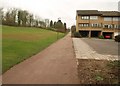
Path, Conniburrow
A long path (continuing the one shown in Image), running in a straight line parallel to the Portway, which is at the top of the slope on the left, and climbing steadily towards Bradwell Common.
Image: © Derek Harper
Taken: 4 Feb 2011
0.20 miles
2
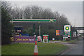
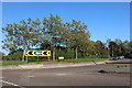
Milton Keynes : BP Petrol Station
A petrol station off of Portway.
Image: © Lewis Clarke
Taken: 24 Mar 2018
0.22 miles
3
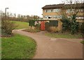
Path, Conniburrow
The path, emerging from beneath Marlborough Street near the Belvedere Roundabout, twists path the rear of houses on Yarrow Place.
Image: © Derek Harper
Taken: 4 Feb 2011
0.22 miles
4
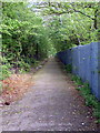
Path to Neath Hill past school playing fields and allotments
Image: © Philip Jeffrey
Taken: 30 Apr 2012
0.22 miles
5
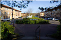
Cranesbill Place, Milton Keynes
Looking north-west along the street from the steps leading to the overbridge on the A509 Portway
Image: © Paul Harrop
Taken: 15 Mar 2009
0.24 miles
6
North Secklow Roundabout, Conniburrow, Milton Keynes
Thank goodness all the roundabout are named, I'd have had terrible trouble finding them all otherwise.
Image: © David Howard
Taken: 13 Sep 2020
0.24 miles