IMAGES TAKEN NEAR TO
Woodruff Avenue, MILTON KEYNES, MK14 7DN
Introduction
This page details the photographs taken nearby to Woodruff Avenue, MK14 7DN by members of the Geograph project.
The Geograph project started in 2005 with the aim of publishing, organising and preserving representative images for every square kilometre of Great Britain, Ireland and the Isle of Man.

There are currently over 7.5m images from over14,400 individuals and you can help contribute to the project by visiting https://www.geograph.org.uk
Image Map
Images are licensed for reuse under creativecommons.org/licenses/by-sa/2.0
Notes
- Clicking on the map will re-center to the selected point.
- The higher the marker number, the further away the image location is from the centre of the postcode.
Image Listing (3 Images Found)
Images are licensed for reuse under creativecommons.org/licenses/by-sa/2.0
Image
Details
Distance
1
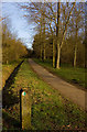
Linford Wood footpath, Milton Keynes
Path leading into the woods just north of Dansteed Way
Image: © Paul Harrop
Taken: 15 Mar 2009
0.19 miles
2
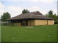
Conniburrow Pavilion
The pavilion building on Conniburrow, found on the boulevard just before the bridge into Bradwell Common.
Image: © Mr Biz
Taken: 25 Jul 2006
0.23 miles
3
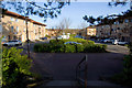
Cranesbill Place, Milton Keynes
Looking north-west along the street from the steps leading to the overbridge on the A509 Portway
Image: © Paul Harrop
Taken: 15 Mar 2009
0.24 miles