IMAGES TAKEN NEAR TO
Kirkeby Close, MILTON KEYNES, MK14 6TA
Introduction
This page details the photographs taken nearby to Kirkeby Close, MK14 6TA by members of the Geograph project.
The Geograph project started in 2005 with the aim of publishing, organising and preserving representative images for every square kilometre of Great Britain, Ireland and the Isle of Man.

There are currently over 7.5m images from over14,400 individuals and you can help contribute to the project by visiting https://www.geograph.org.uk
Image Map
Images are licensed for reuse under creativecommons.org/licenses/by-sa/2.0
Notes
- Clicking on the map will re-center to the selected point.
- The higher the marker number, the further away the image location is from the centre of the postcode.
Image Listing (4 Images Found)
Images are licensed for reuse under creativecommons.org/licenses/by-sa/2.0
Image
Details
Distance
1
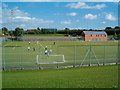
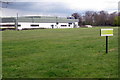
Stantonbury Sports
Stantonbury has fantastic sports facilities, as can be seen from the astroturf pitches in the foreground and the athletics track in the midground. On the right is the recently built pavilion for the athletics track, which is home to Milton Keynes Athletics Club.
Image: © Richard Schmidt
Taken: 3 Sep 2006
0.12 miles
2
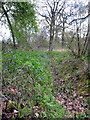
Industrial Unit on the edge of Linford Wood
Image: © Philip Jeffrey
Taken: 22 Apr 2012
0.14 miles
3

Milton Keynes : H3 Monks Way
Looking along Monks Way.
Image: © Lewis Clarke
Taken: 18 Mar 2019
0.20 miles