IMAGES TAKEN NEAR TO
Salters Mews, MILTON KEYNES, MK14 6HF
Introduction
This page details the photographs taken nearby to Salters Mews, MK14 6HF by members of the Geograph project.
The Geograph project started in 2005 with the aim of publishing, organising and preserving representative images for every square kilometre of Great Britain, Ireland and the Isle of Man.

There are currently over 7.5m images from over14,400 individuals and you can help contribute to the project by visiting https://www.geograph.org.uk
Image Map
Images are licensed for reuse under creativecommons.org/licenses/by-sa/2.0
Notes
- Clicking on the map will re-center to the selected point.
- The higher the marker number, the further away the image location is from the centre of the postcode.
Image Listing (6 Images Found)
Images are licensed for reuse under creativecommons.org/licenses/by-sa/2.0
Image
Details
Distance
1

Milton Keynes : Currier Drive
A road heading off from Marlborough Street.
Image: © Lewis Clarke
Taken: 24 Mar 2018
0.18 miles
2
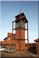
Clock Tower at Neath Hill Shopping Precinct, Milton Keynes
Image: © Colin Park
Taken: 25 Jan 1984
0.19 miles
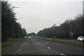
3
Milton Keynes : Marlborough Street B4034
Looking along a road heading through Milton Keynes.
Image: © Lewis Clarke
Taken: 24 Mar 2018
0.21 miles
4
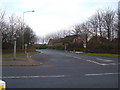
Entrance to Neath Hill
A road junction into the Neath Hill estate off the B4034 V8 Marlborough Street.
Image: © Mr Biz
Taken: 15 Feb 2009
0.23 miles
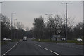
5
Milton Keynes : Monks Way A422
Looking along Monks Way as it heads through Milton Keynes.
Image: © Lewis Clarke
Taken: 24 Mar 2018
0.24 miles
6
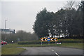
Milton Keynes : Redbridge Roundabout
Approaching Redbridge Roundabout from Monks Way.
Image: © Lewis Clarke
Taken: 24 Mar 2018
0.24 miles