IMAGES TAKEN NEAR TO
Dyers Mews, MILTON KEYNES, MK14 6ER
Introduction
This page details the photographs taken nearby to Dyers Mews, MK14 6ER by members of the Geograph project.
The Geograph project started in 2005 with the aim of publishing, organising and preserving representative images for every square kilometre of Great Britain, Ireland and the Isle of Man.

There are currently over 7.5m images from over14,400 individuals and you can help contribute to the project by visiting https://www.geograph.org.uk
Image Map
Images are licensed for reuse under creativecommons.org/licenses/by-sa/2.0
Notes
- Clicking on the map will re-center to the selected point.
- The higher the marker number, the further away the image location is from the centre of the postcode.
Image Listing (5 Images Found)
Images are licensed for reuse under creativecommons.org/licenses/by-sa/2.0
Image
Details
Distance
1
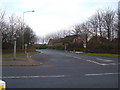
Entrance to Neath Hill
A road junction into the Neath Hill estate off the B4034 V8 Marlborough Street.
Image: © Mr Biz
Taken: 15 Feb 2009
0.08 miles
2
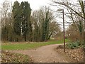
Paths, Downs Barn
The path has just emerged from under a bridge carrying Capel Drive and now runs (right) parallel to Dansteed Way. The turn to the left runs past Woodlands Day Nursery to Byerly Place.
Image: © Derek Harper
Taken: 4 Feb 2011
0.16 miles
3
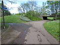
Path and underpass towards Linford Wood
Image: © Philip Jeffrey
Taken: 30 Apr 2012
0.16 miles
4
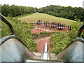
The BIG Slide
A Play area in Downs Barn, one of over 500 in the New City. In the background can be seen a Redway, one of the foot/cycle paths networked across Milton Keynes.
Image: © Richard Schmidt
Taken: 2 Aug 2006
0.19 miles
5
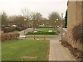
Martingale Place, Downs Barn
The road continues as a wide dual carriageway boulevard into Pelham Place across Downs Barn Boulevard, which is even wider.
Image: © Derek Harper
Taken: 4 Feb 2011
0.19 miles