IMAGES TAKEN NEAR TO
Salisbury Grove, MILTON KEYNES, MK14 5QA
Introduction
This page details the photographs taken nearby to Salisbury Grove, MK14 5QA by members of the Geograph project.
The Geograph project started in 2005 with the aim of publishing, organising and preserving representative images for every square kilometre of Great Britain, Ireland and the Isle of Man.

There are currently over 7.5m images from over14,400 individuals and you can help contribute to the project by visiting https://www.geograph.org.uk
Image Map
Images are licensed for reuse under creativecommons.org/licenses/by-sa/2.0
Notes
- Clicking on the map will re-center to the selected point.
- The higher the marker number, the further away the image location is from the centre of the postcode.
Image Listing (20 Images Found)
Images are licensed for reuse under creativecommons.org/licenses/by-sa/2.0
Image
Details
Distance
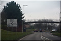
1
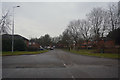
Milton Keynes : Horton Gate
A road heading off from Brickhill Street.
Image: © Lewis Clarke
Taken: 24 Mar 2018
0.13 miles
2
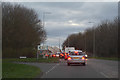
Milton Keynes : Brickhill Street
Looking along Brickhill Street.
Image: © Lewis Clarke
Taken: 18 Mar 2019
0.14 miles
3

Milton Keynes : Tanners Drive
A road heading off from Brickhill Street into Blakelands Industrial Estate.
Image: © Lewis Clarke
Taken: 24 Mar 2018
0.17 miles
4
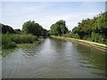
Grand Union Canal: Reach in Giffard Park
For the most part the canal is shielded from the houses in the new residential suburbs of Milton Keynes (and vice versa). Here the houses in Bromham Mill are hidden behind the high hedge at the back of the towpath on the right.
Image: © Nigel Cox
Taken: 1 Sep 2013
0.19 miles
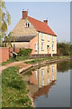
5
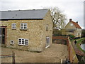
The Old Wharf Great Linford
Before being converted into a dwelling the old wharf building was an agricultural machinery factory. Originally there was a branch from the canal which ran by the far side of this building, during the last war tractors were shipped from the USA in knock-down packs and brought up the Grand Union to the Old Wharf to be assembled and sold to local farmers and contractors as part of the war effort.
Image: © David M Jones
Taken: 23 Feb 2008
0.19 miles
6
Milton Keynes : Brickhill Street
Looking along Brickhill Street.
Image: © Lewis Clarke
Taken: 24 Mar 2018
0.21 miles
7
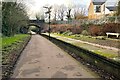
Great Linford Station on the Railway Walk
Was on the Newport Pagnell to Wolverton line until it was Beechinged in 1964
Image: © Philip Jeffrey
Taken: 29 Jan 2023
0.21 miles
9

The Wharf, Great Linford
Old building on the canal at Great Linford viewed from the bridge.
Image: © mick finn
Taken: 19 Apr 2009
0.21 miles
10
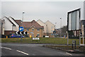
Milton Keynes : Giffard Park Roundabout
Looking towards a roundabout from Brickhill Street.
Image: © Lewis Clarke
Taken: 24 Mar 2018
0.21 miles