IMAGES TAKEN NEAR TO
Barbury Court, MILTON KEYNES, MK14 5PT
Introduction
This page details the photographs taken nearby to Barbury Court, MK14 5PT by members of the Geograph project.
The Geograph project started in 2005 with the aim of publishing, organising and preserving representative images for every square kilometre of Great Britain, Ireland and the Isle of Man.

There are currently over 7.5m images from over14,400 individuals and you can help contribute to the project by visiting https://www.geograph.org.uk
Image Map
Images are licensed for reuse under creativecommons.org/licenses/by-sa/2.0
Notes
- Clicking on the map will re-center to the selected point.
- The higher the marker number, the further away the image location is from the centre of the postcode.
Image Listing (29 Images Found)
Images are licensed for reuse under creativecommons.org/licenses/by-sa/2.0
Image
Details
Distance
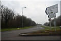
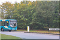
1
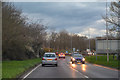
Milton Keynes : Brickhill Street
Looking along Brickhill Street.
Image: © Lewis Clarke
Taken: 18 Mar 2019
0.05 miles
3
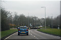
Milton Keynes : Brickhill Street
Heading through Milton Keynes on Brickhill Street.
Image: © Lewis Clarke
Taken: 24 Mar 2018
0.06 miles
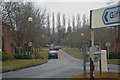
4
Milton Keynes : Brickhill Street
Looking along Brickhill Street in Milton Keynes.
Image: © Lewis Clarke
Taken: 24 Mar 2018
0.07 miles
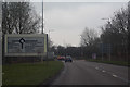
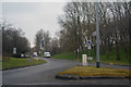
5
Milton Keynes : Monks Way A422
A road heading off from the roundabout.
Image: © Lewis Clarke
Taken: 24 Mar 2018
0.10 miles
6
Milton Keynes : Clayton Gate
Looking along Clayton Gate.
Image: © Lewis Clarke
Taken: 24 Mar 2018
0.10 miles
7
Milton Keynes : Yeomans Drive
A road heading off from Brickhill Street.
Image: © Lewis Clarke
Taken: 24 Mar 2018
0.12 miles
8
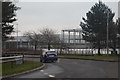
Milton Keynes : Monks Way A422
A road heading off from the roundabout.
Image: © Lewis Clarke
Taken: 24 Mar 2018
0.12 miles
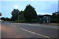
9
Milton Keynes : V10 Brickhill Street
Looking towards Brickhill Street off Monks Way.
Image: © Lewis Clarke
Taken: 6 Oct 2018
0.14 miles
10
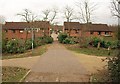
Path crossing by the canal
Taken at the edge of a foot / cycle bridge across the Grand Union Canal, with signs indicating the routes along the towpath to left and right. Ahead, Wandlebury dives into Bolbeck Park.
Image: © Derek Harper
Taken: 4 Feb 2011
0.16 miles