IMAGES TAKEN NEAR TO
Hambledines, MILTON KEYNES, MK14 5FS
Introduction
This page details the photographs taken nearby to Hambledines, MK14 5FS by members of the Geograph project.
The Geograph project started in 2005 with the aim of publishing, organising and preserving representative images for every square kilometre of Great Britain, Ireland and the Isle of Man.

There are currently over 7.5m images from over14,400 individuals and you can help contribute to the project by visiting https://www.geograph.org.uk
Image Map
Images are licensed for reuse under creativecommons.org/licenses/by-sa/2.0
Notes
- Clicking on the map will re-center to the selected point.
- The higher the marker number, the further away the image location is from the centre of the postcode.
Image Listing (4 Images Found)
Images are licensed for reuse under creativecommons.org/licenses/by-sa/2.0
Image
Details
Distance
1
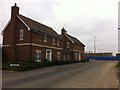
Cape End
New detached houses in Gifford Park.
Image: © Burgess Von Thunen
Taken: 28 Nov 2013
0.19 miles
2
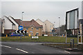
Milton Keynes : Giffard Park Roundabout
Looking towards a roundabout from Brickhill Street.
Image: © Lewis Clarke
Taken: 24 Mar 2018
0.21 miles
3
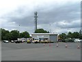
CMG Rescue Services, Newport Pagnell, M1 northbound
A breakdown and rescue company based at the Newport Pagnell motorway services on the M1 northbound.
Image: © David P Howard
Taken: 17 Jul 2010
0.24 miles
4
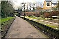
Great Linford Station on the Railway Walk
Was on the Newport Pagnell to Wolverton line until it was Beechinged in 1964
Image: © Philip Jeffrey
Taken: 29 Jan 2023
0.24 miles