IMAGES TAKEN NEAR TO
Yeomans Drive, MILTON KEYNES, MK14 5AN
Introduction
This page details the photographs taken nearby to Yeomans Drive, MK14 5AN by members of the Geograph project.
The Geograph project started in 2005 with the aim of publishing, organising and preserving representative images for every square kilometre of Great Britain, Ireland and the Isle of Man.

There are currently over 7.5m images from over14,400 individuals and you can help contribute to the project by visiting https://www.geograph.org.uk
Image Map
Images are licensed for reuse under creativecommons.org/licenses/by-sa/2.0
Notes
- Clicking on the map will re-center to the selected point.
- The higher the marker number, the further away the image location is from the centre of the postcode.
Image Listing (10 Images Found)
Images are licensed for reuse under creativecommons.org/licenses/by-sa/2.0
Image
Details
Distance
1
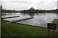
Landing stages in Tongwell Lake
With the island in the background
Image: © Philip Jeffrey
Taken: 29 Apr 2012
0.12 miles
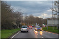
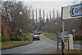
2
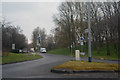
Milton Keynes : Yeomans Drive
A road heading off from Brickhill Street.
Image: © Lewis Clarke
Taken: 24 Mar 2018
0.21 miles
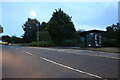
3
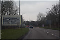
Milton Keynes : Brickhill Street
Looking along Brickhill Street in Milton Keynes.
Image: © Lewis Clarke
Taken: 24 Mar 2018
0.21 miles
4
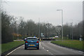
Milton Keynes : Brickhill Street
Heading through Milton Keynes on Brickhill Street.
Image: © Lewis Clarke
Taken: 24 Mar 2018
0.22 miles
5
Milton Keynes : Brickhill Street
Looking along Brickhill Street.
Image: © Lewis Clarke
Taken: 18 Mar 2019
0.22 miles
7
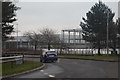
Milton Keynes : Monks Way A422
A road heading off from the roundabout.
Image: © Lewis Clarke
Taken: 24 Mar 2018
0.23 miles
8
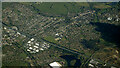
Newport Pagnell from the air
North of Milton Keynes and the M1 motorway.
Image: © Thomas Nugent
Taken: 17 Apr 2024
0.24 miles
9
Milton Keynes : Clayton Gate
Looking along Clayton Gate.
Image: © Lewis Clarke
Taken: 24 Mar 2018
0.24 miles
10
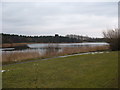
Tongwell Lake
Another of the man made lakes in Milton Keynes to help with flood control. The lake takes its name from Tongwell Farm, which most of this area used to belong to before the creation of Milton Keynes
Image: © Mr Biz
Taken: 15 Feb 2009
0.25 miles