IMAGES TAKEN NEAR TO
Quinton Drive, MILTON KEYNES, MK13 9HP
Introduction
This page details the photographs taken nearby to Quinton Drive, MK13 9HP by members of the Geograph project.
The Geograph project started in 2005 with the aim of publishing, organising and preserving representative images for every square kilometre of Great Britain, Ireland and the Isle of Man.

There are currently over 7.5m images from over14,400 individuals and you can help contribute to the project by visiting https://www.geograph.org.uk
Image Map
Images are licensed for reuse under creativecommons.org/licenses/by-sa/2.0
Notes
- Clicking on the map will re-center to the selected point.
- The higher the marker number, the further away the image location is from the centre of the postcode.
Image Listing (21 Images Found)
Images are licensed for reuse under creativecommons.org/licenses/by-sa/2.0
Image
Details
Distance
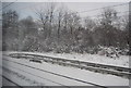
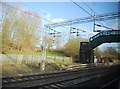
2
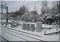
Railway infrastructure, West Coast Main Line
Image: © N Chadwick
Taken: 19 Dec 2010
0.17 miles
3
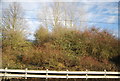
Vegetated slope by the West Coast Main Line
Image: © N Chadwick
Taken: 22 Dec 2013
0.19 miles

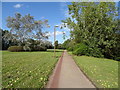
6
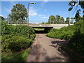
Underpass beneath Grafton Street
Used by a cycle path.
Image: © JThomas
Taken: 17 Aug 2019
0.22 miles
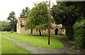
7
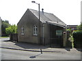
Bradwell Chapel
The Chapel building in Bradwell has a very small capacity of 20 persons and is used for meetings only.
Image: © Mr Biz
Taken: 25 Jul 2006
0.23 miles