IMAGES TAKEN NEAR TO
The Spinney, MILTON KEYNES, MK13 9BX
Introduction
This page details the photographs taken nearby to The Spinney, MK13 9BX by members of the Geograph project.
The Geograph project started in 2005 with the aim of publishing, organising and preserving representative images for every square kilometre of Great Britain, Ireland and the Isle of Man.

There are currently over 7.5m images from over14,400 individuals and you can help contribute to the project by visiting https://www.geograph.org.uk
Image Map
Images are licensed for reuse under creativecommons.org/licenses/by-sa/2.0
Notes
- Clicking on the map will re-center to the selected point.
- The higher the marker number, the further away the image location is from the centre of the postcode.
Image Listing (39 Images Found)
Images are licensed for reuse under creativecommons.org/licenses/by-sa/2.0
Image
Details
Distance
1
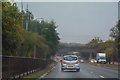
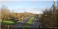
Milton Keynes : H3 Monks Way
Looking along the road with Colley Hill to the right.
Image: © Lewis Clarke
Taken: 18 Mar 2019
0.10 miles
2
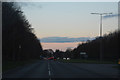
Milton Keynes : H3 Monks Way A422
Looking along Monks Way on a wet morning.
Image: © Lewis Clarke
Taken: 6 Oct 2018
0.12 miles
4
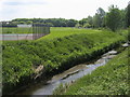
Loughton Brook
Loughton Brook passing the Old Bradwell tennis club
Image: © Shaun Ferguson
Taken: 16 May 2014
0.16 miles
5
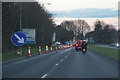
Milton Keynes : H3 Monks Way
Approaching the roundabout.
Image: © Lewis Clarke
Taken: 18 Mar 2019
0.18 miles
7
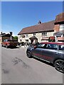
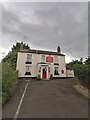
The Victoria Inn, Bradwell village
The Victoria Inn at Bradwell village on a Saturday afternoon
Image: © Ryan Griffiths
Taken: 29 May 2021
0.18 miles
8
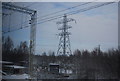
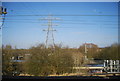
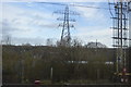
Sub Station and Pylon by the West Coast Main Line
Image: © N Chadwick
Taken: 19 Dec 2010
0.19 miles