IMAGES TAKEN NEAR TO
The Grove, MILTON KEYNES, MK13 9AU
Introduction
This page details the photographs taken nearby to The Grove, MK13 9AU by members of the Geograph project.
The Geograph project started in 2005 with the aim of publishing, organising and preserving representative images for every square kilometre of Great Britain, Ireland and the Isle of Man.

There are currently over 7.5m images from over14,400 individuals and you can help contribute to the project by visiting https://www.geograph.org.uk
Image Map
Images are licensed for reuse under creativecommons.org/licenses/by-sa/2.0
Notes
- Clicking on the map will re-center to the selected point.
- The higher the marker number, the further away the image location is from the centre of the postcode.
Image Listing (32 Images Found)
Images are licensed for reuse under creativecommons.org/licenses/by-sa/2.0
Image
Details
Distance
1
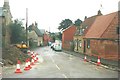
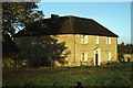
Vicarage Road, Bradwell in 1987
The nameplate on the wall of the thatched house reads Alexandra Court
Image: © John Baker
Taken: 9 Oct 1987
0.07 miles
2
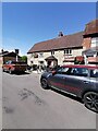
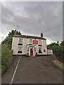
The Victoria Inn, Bradwell village
The Victoria Inn at Bradwell village on a Saturday afternoon
Image: © Ryan Griffiths
Taken: 29 May 2021
0.07 miles
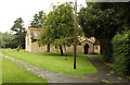
4
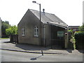
Bradwell Chapel
The Chapel building in Bradwell has a very small capacity of 20 persons and is used for meetings only.
Image: © Mr Biz
Taken: 25 Jul 2006
0.08 miles
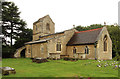
6
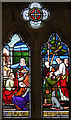
St Lawrence, Bradwell - Stained glass window
Image: © John Salmon
Taken: 10 Sep 2016
0.16 miles
7
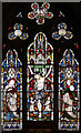
St Lawrence, Bradwell - Stained glass window
Image: © John Salmon
Taken: 10 Sep 2016
0.16 miles
8

St Lawrence, Bradwell - Stained glass window
Image: © John Salmon
Taken: 10 Sep 2016
0.16 miles