IMAGES TAKEN NEAR TO
Hadley Place, MILTON KEYNES, MK13 8RL
Introduction
This page details the photographs taken nearby to Hadley Place, MK13 8RL by members of the Geograph project.
The Geograph project started in 2005 with the aim of publishing, organising and preserving representative images for every square kilometre of Great Britain, Ireland and the Isle of Man.

There are currently over 7.5m images from over14,400 individuals and you can help contribute to the project by visiting https://www.geograph.org.uk
Image Map
Images are licensed for reuse under creativecommons.org/licenses/by-sa/2.0
Notes
- Clicking on the map will re-center to the selected point.
- The higher the marker number, the further away the image location is from the centre of the postcode.
Image Listing (8 Images Found)
Images are licensed for reuse under creativecommons.org/licenses/by-sa/2.0
Image
Details
Distance
1
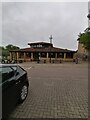
The Countryman, Bradwell Common
The Countryman at Bradwell Common, MK
Image: © Ryan Griffiths
Taken: 19 Jun 2021
0.16 miles
2
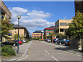
North Third Street, Central Milton Keynes
Image: © Rodney Burton
Taken: 7 Sep 2006
0.18 miles
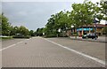
4
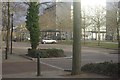
Midsummer Boulevard, Milton Keynes
A view typical of Central Milton Keynes (often abbreviated to CMK) where Midsummer Boulevard intersects Fourth Street.
Image: © Stephen McKay
Taken: 7 Jan 2012
0.22 miles
5
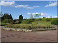
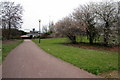
Cycle path roundabout, Central Milton Keynes
In the centre of a road roundabout.
Image: © JThomas
Taken: 17 Aug 2019
0.23 miles
6
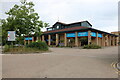
Willen Hospice Shop in Milton Keynes
This was Office World but they are no more anywhere.
Image: © David Howard
Taken: 22 Aug 2021
0.23 miles
7
Shopping centre by Silbury Boulevard, Milton Keynes
Image: © David Howard
Taken: 22 Aug 2021
0.25 miles
8
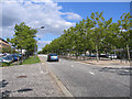
Silbury Boulevard, Central Milton Keynes
Rus in urbe.
Image: © Rodney Burton
Taken: 7 Sep 2006
0.25 miles