IMAGES TAKEN NEAR TO
Arncliffe Drive, MILTON KEYNES, MK13 7LJ
Introduction
This page details the photographs taken nearby to Arncliffe Drive, MK13 7LJ by members of the Geograph project.
The Geograph project started in 2005 with the aim of publishing, organising and preserving representative images for every square kilometre of Great Britain, Ireland and the Isle of Man.

There are currently over 7.5m images from over14,400 individuals and you can help contribute to the project by visiting https://www.geograph.org.uk
Image Map
Images are licensed for reuse under creativecommons.org/licenses/by-sa/2.0
Notes
- Clicking on the map will re-center to the selected point.
- The higher the marker number, the further away the image location is from the centre of the postcode.
Image Listing (5 Images Found)
Images are licensed for reuse under creativecommons.org/licenses/by-sa/2.0
Image
Details
Distance
1
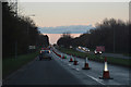
Milton Keynes : H3 Monks Way
Heading along H3 Monks Way.
Image: © Lewis Clarke
Taken: 18 Mar 2019
0.19 miles

4
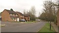
Mercers Drive, Bradville
From the junction with Abbey Way, looking past the junction with Donnington (left) and Shipton Hill.
Image: © Derek Harper
Taken: 4 Feb 2011
0.24 miles
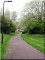
5
Summergill Court, Milton Keynes
Short residential cul-de-sac in the Heelands area
Image: © Paul Harrop
Taken: 15 Mar 2009
0.24 miles