IMAGES TAKEN NEAR TO
Harrowden, MILTON KEYNES, MK13 7DB
Introduction
This page details the photographs taken nearby to Harrowden, MK13 7DB by members of the Geograph project.
The Geograph project started in 2005 with the aim of publishing, organising and preserving representative images for every square kilometre of Great Britain, Ireland and the Isle of Man.

There are currently over 7.5m images from over14,400 individuals and you can help contribute to the project by visiting https://www.geograph.org.uk
Image Map
Images are licensed for reuse under creativecommons.org/licenses/by-sa/2.0
Notes
- Clicking on the map will re-center to the selected point.
- The higher the marker number, the further away the image location is from the centre of the postcode.
Image Listing (21 Images Found)
Images are licensed for reuse under creativecommons.org/licenses/by-sa/2.0
Image
Details
Distance
2
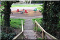
Playground seen from the Railway Walk
Image: © Philip Jeffrey
Taken: 14 Apr 2012
0.11 miles
6
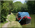
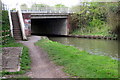
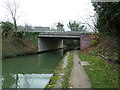
Narrowboat moored along the Grand Union Canal
This stretch of the canal is between bridges 72 and 74, in the New Bradwell area of Milton Keynes.
Image: © Mat Fascione
Taken: 8 Aug 2015
0.14 miles
7
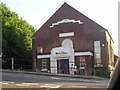
New Life Church, New Bradwell, Milton Keynes
Image: © Godfrey Pocock
Taken: 8 Jul 2003
0.15 miles