IMAGES TAKEN NEAR TO
Stanton Avenue, MILTON KEYNES, MK13 7AU
Introduction
This page details the photographs taken nearby to Stanton Avenue, MK13 7AU by members of the Geograph project.
The Geograph project started in 2005 with the aim of publishing, organising and preserving representative images for every square kilometre of Great Britain, Ireland and the Isle of Man.

There are currently over 7.5m images from over14,400 individuals and you can help contribute to the project by visiting https://www.geograph.org.uk
Image Map
Images are licensed for reuse under creativecommons.org/licenses/by-sa/2.0
Notes
- Clicking on the map will re-center to the selected point.
- The higher the marker number, the further away the image location is from the centre of the postcode.
Image Listing (6 Images Found)
Images are licensed for reuse under creativecommons.org/licenses/by-sa/2.0
Image
Details
Distance
1
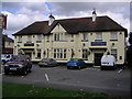
Halleys Commet Public House
Although on one of Milton Keynes estates (Bradville), this public house stands on Bradwell Road, which has been around far longer than the "grid system" of MK, as has much of Bradville.
Image: © Mr Biz
Taken: 27 Aug 2006
0.12 miles
2
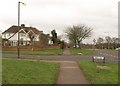
Abbey Way meets Bradwell Road
The fact that the streetlight overhead is illuminated shows just what a miserably gloomy day this was (very cold as well), and this mundane scene doesn't help either.
Image: © Derek Harper
Taken: 4 Feb 2011
0.15 miles
3
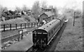
Bradwell Station, with train
View NE, towards Newport Pagnell; ex-LNW Wolverton - Newport Pagnell branch. Station and branch closed to passengers 7/9/64, for goods 22/5/67. An auto-train is working the branch, powered by an Ivatt Class 3MT 2-6-2T. (The site is of course now enveloped in the New Town of Milton Keynes).
Image: © Ben Brooksbank
Taken: 12 May 1962
0.24 miles
4
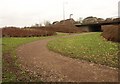
Cycle / foot path, Bradville
The path has emerged from the Loughton Brook valley and here curves beneath Grafton Street into the Bradville Street.
Image: © Derek Harper
Taken: 4 Feb 2011
0.24 miles
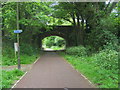
5
Bridge over cyclepath, Milton Keynes
Bradwell Road crosses the path shown in Image, using an old railway bridge.
Image: © Derek Harper
Taken: 4 Feb 2011
0.25 miles
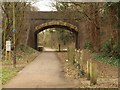
6
Swan's Way
Swan's Way heading under the Bradwell Road bridge along the old railway line
Image: © Shaun Ferguson
Taken: 16 May 2014
0.25 miles