IMAGES TAKEN NEAR TO
Hadrians Drive, MILTON KEYNES, MK13 0QB
Introduction
This page details the photographs taken nearby to Hadrians Drive, MK13 0QB by members of the Geograph project.
The Geograph project started in 2005 with the aim of publishing, organising and preserving representative images for every square kilometre of Great Britain, Ireland and the Isle of Man.

There are currently over 7.5m images from over14,400 individuals and you can help contribute to the project by visiting https://www.geograph.org.uk
Image Map
Images are licensed for reuse under creativecommons.org/licenses/by-sa/2.0
Notes
- Clicking on the map will re-center to the selected point.
- The higher the marker number, the further away the image location is from the centre of the postcode.
Image Listing (7 Images Found)
Images are licensed for reuse under creativecommons.org/licenses/by-sa/2.0
Image
Details
Distance
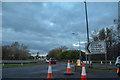
2
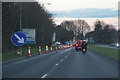
Milton Keynes : H3 Monks Way
Approaching the roundabout.
Image: © Lewis Clarke
Taken: 18 Mar 2019
0.12 miles
3
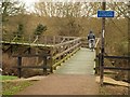
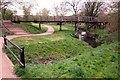
Footbridge, North Loughton Valley Park
"Doesn't apply to me". A cyclist rides over a footbridge across the Loughton Brook.
Image: © Derek Harper
Taken: 4 Feb 2011
0.13 miles
4
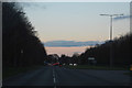
Milton Keynes : H3 Monks Way
Looking along the road with Colley Hill to the right.
Image: © Lewis Clarke
Taken: 18 Mar 2019
0.15 miles
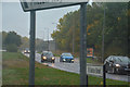
5
Milton Keynes : V6 Grafton Street
From the Bancroft Roundabout.
Image: © Lewis Clarke
Taken: 18 Mar 2019
0.17 miles
6
Milton Keynes : V6 Grafton Street
Looking off from Monks Way.
Image: © Lewis Clarke
Taken: 6 Oct 2018
0.22 miles
7
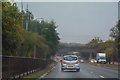
Milton Keynes : H3 Monks Way A422
Looking along Monks Way on a wet morning.
Image: © Lewis Clarke
Taken: 6 Oct 2018
0.25 miles