IMAGES TAKEN NEAR TO
Newport Road, MILTON KEYNES, MK13 0AW
Introduction
This page details the photographs taken nearby to Newport Road, MK13 0AW by members of the Geograph project.
The Geograph project started in 2005 with the aim of publishing, organising and preserving representative images for every square kilometre of Great Britain, Ireland and the Isle of Man.

There are currently over 7.5m images from over14,400 individuals and you can help contribute to the project by visiting https://www.geograph.org.uk
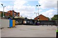
Image Map
Images are licensed for reuse under creativecommons.org/licenses/by-sa/2.0
Notes
- Clicking on the map will re-center to the selected point.
- The higher the marker number, the further away the image location is from the centre of the postcode.
Image Listing (46 Images Found)
Images are licensed for reuse under creativecommons.org/licenses/by-sa/2.0
Image
Details
Distance
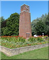
2
British Legion Memorial, New Bradwell, Milton Keynes
Dedicated in 1962.
Image: © Stuart and Fiona Jackson
Taken: 14 Jul 2005
0.08 miles
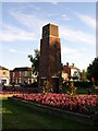
3
St James, New Bradwell - War Memorial WWI & WWII
Image: © John Salmon
Taken: 10 Sep 2016
0.08 miles
4
Bridge carrying Stratford Road over the West Coast Main Line at Wolverton
Image: © Tim Glover
Taken: 26 May 2012
0.22 miles
6
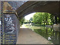
Wolverton Bridge No 71
Carrying Stratford Road across the Grand Union Canal in Milton Keynes.
Image: © Mat Fascione
Taken: 8 Aug 2015
0.22 miles
7
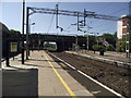
Wolverton railway station
On the West Coast Main Line.
Image: © Andrew Abbott
Taken: 19 May 2021
0.22 miles
8

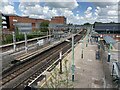
A Virgin train races through Wolverton Station
Image: © Steve Daniels
Taken: 17 Jul 2010
0.23 miles
9
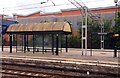
The ticket office and cycle rack at Wolverton Station
Image: © Steve Daniels
Taken: 17 Jul 2010
0.23 miles