IMAGES TAKEN NEAR TO
Mapledean, MILTON KEYNES, MK12 6HD
Introduction
This page details the photographs taken nearby to Mapledean, MK12 6HD by members of the Geograph project.
The Geograph project started in 2005 with the aim of publishing, organising and preserving representative images for every square kilometre of Great Britain, Ireland and the Isle of Man.

There are currently over 7.5m images from over14,400 individuals and you can help contribute to the project by visiting https://www.geograph.org.uk
Image Map
Images are licensed for reuse under creativecommons.org/licenses/by-sa/2.0
Notes
- Clicking on the map will re-center to the selected point.
- The higher the marker number, the further away the image location is from the centre of the postcode.
Image Listing (7 Images Found)
Images are licensed for reuse under creativecommons.org/licenses/by-sa/2.0
Image
Details
Distance
5
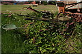
Milton Keynes Museum's graveyard
In every other respect a fabulous place, cannot recommend it enough, but certain items seem to have been abandoned to their fate. Pity they were moved from their former position on the hard-standing.
Image: © Chris
Taken: 28 May 2015
0.20 miles
6
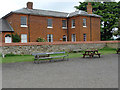
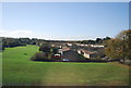
Stacey Hill Farmhouse, Milton Keynes Museum
The Museum is located in the peaceful surroundings of Stacey Hill Farm. Stacey Hill Farm was built early in the Victorian era as a model farm. It was located on the outskirts of Wolverton, one of the UK's original "railway towns".
Image: © Cameraman
Taken: 10 Jun 2010
0.22 miles
7

Milton Keynes Museum entrance and shop
Image: © Steve Daniels
Taken: 17 Jul 2010
0.25 miles