IMAGES TAKEN NEAR TO
Haversham Road, MILTON KEYNES, MK12 5TN
Introduction
This page details the photographs taken nearby to Haversham Road, MK12 5TN by members of the Geograph project.
The Geograph project started in 2005 with the aim of publishing, organising and preserving representative images for every square kilometre of Great Britain, Ireland and the Isle of Man.

There are currently over 7.5m images from over14,400 individuals and you can help contribute to the project by visiting https://www.geograph.org.uk
Image Map
Images are licensed for reuse under creativecommons.org/licenses/by-sa/2.0
Notes
- Clicking on the map will re-center to the selected point.
- The higher the marker number, the further away the image location is from the centre of the postcode.
Image Listing (59 Images Found)
Images are licensed for reuse under creativecommons.org/licenses/by-sa/2.0
Image
Details
Distance
1
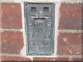
Ordnance Survey Flush Bracket G2317
This can be found on the wall of Millmead Hall.
For more detail see : http://www.bench-marks.org.uk/bm159
Image: © Peter Wood
Taken: 30 Nov 2012
0.02 miles
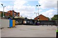
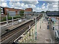
3
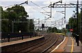
Looking down the line at Wolverton Station
Image: © Steve Daniels
Taken: 17 Jul 2010
0.05 miles
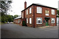
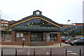
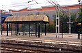
5
The ticket office and cycle rack at Wolverton Station
Image: © Steve Daniels
Taken: 17 Jul 2010
0.08 miles
6
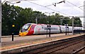
A Virgin train races through Wolverton Station
Image: © Steve Daniels
Taken: 17 Jul 2010
0.09 miles
7
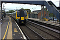
Wolverton station
A London Midland class 350 unit departs for Northampton
Image: © Robert Eva
Taken: 8 May 2017
0.09 miles
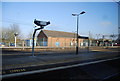
10
Wolverton railway station
On the West Coast Main Line.
Image: © Andrew Abbott
Taken: 19 May 2021
0.11 miles