IMAGES TAKEN NEAR TO
Colts Holm Road, MILTON KEYNES, MK12 5QD
Introduction
This page details the photographs taken nearby to Colts Holm Road, MK12 5QD by members of the Geograph project.
The Geograph project started in 2005 with the aim of publishing, organising and preserving representative images for every square kilometre of Great Britain, Ireland and the Isle of Man.

There are currently over 7.5m images from over14,400 individuals and you can help contribute to the project by visiting https://www.geograph.org.uk
Image Map
Images are licensed for reuse under creativecommons.org/licenses/by-sa/2.0
Notes
- Clicking on the map will re-center to the selected point.
- The higher the marker number, the further away the image location is from the centre of the postcode.
Image Listing (18 Images Found)
Images are licensed for reuse under creativecommons.org/licenses/by-sa/2.0
Image
Details
Distance
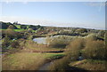
4
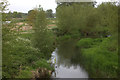
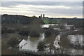
River Great Ouse. Looking west from footbridge
Image: © Robert Eva
Taken: 8 May 2017
0.19 miles
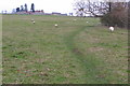
7
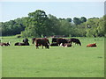
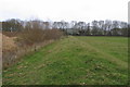
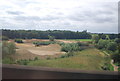
Yes this is Milton Keynes
Neither cows (they're bullocks), nor concrete, but this is still Milton Keynes. A scene from the Ouse Valley Park in Wolverton.
Image: © Richard Schmidt
Taken: 20 May 2007
0.21 miles