IMAGES TAKEN NEAR TO
Old Wolverton Road, MILTON KEYNES, MK12 5NN
Introduction
This page details the photographs taken nearby to Old Wolverton Road, MK12 5NN by members of the Geograph project.
The Geograph project started in 2005 with the aim of publishing, organising and preserving representative images for every square kilometre of Great Britain, Ireland and the Isle of Man.

There are currently over 7.5m images from over14,400 individuals and you can help contribute to the project by visiting https://www.geograph.org.uk
Image Map
Images are licensed for reuse under creativecommons.org/licenses/by-sa/2.0
Notes
- Clicking on the map will re-center to the selected point.
- The higher the marker number, the further away the image location is from the centre of the postcode.
Image Listing (14 Images Found)
Images are licensed for reuse under creativecommons.org/licenses/by-sa/2.0
Image
Details
Distance
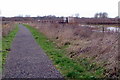
3
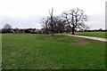
Footpath towards the canal
Through the deserted village
Image: © Philip Jeffrey
Taken: 27 Jan 2019
0.13 miles
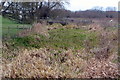
4
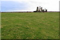
Deserted medieval village of Wolverton
With Manor farm beyond
Image: © Philip Jeffrey
Taken: 27 Jan 2019
0.16 miles