IMAGES TAKEN NEAR TO
Grange Court, MILTON KEYNES, MK12 5NE
Introduction
This page details the photographs taken nearby to Grange Court, MK12 5NE by members of the Geograph project.
The Geograph project started in 2005 with the aim of publishing, organising and preserving representative images for every square kilometre of Great Britain, Ireland and the Isle of Man.

There are currently over 7.5m images from over14,400 individuals and you can help contribute to the project by visiting https://www.geograph.org.uk
Image Map
Images are licensed for reuse under creativecommons.org/licenses/by-sa/2.0
Notes
- Clicking on the map will re-center to the selected point.
- The higher the marker number, the further away the image location is from the centre of the postcode.
Image Listing (12 Images Found)
Images are licensed for reuse under creativecommons.org/licenses/by-sa/2.0
Image
Details
Distance
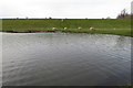
1
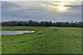
Sheep by the Wolverton Mill balancing lakes
Image: © Philip Jeffrey
Taken: 14 Mar 2018
0.05 miles
3
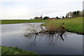
Water management lake at Wolverton Mill
Image: © Philip Jeffrey
Taken: 14 Mar 2018
0.10 miles
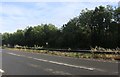
5
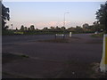
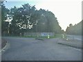
Harnett Drive at the junction of Stratford Road
Image: © David Howard
Taken: 8 Aug 2012
0.13 miles
6
Harnett Drive at the junction of Stratford Road
Image: © David Howard
Taken: 8 Aug 2012
0.13 miles
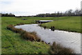
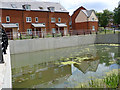
7
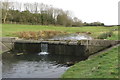
Weir and stepping stones on the balancing lake
Image: © Philip Jeffrey
Taken: 14 Mar 2018
0.14 miles