IMAGES TAKEN NEAR TO
Church Street, MILTON KEYNES, MK12 5LB
Introduction
This page details the photographs taken nearby to Church Street, MK12 5LB by members of the Geograph project.
The Geograph project started in 2005 with the aim of publishing, organising and preserving representative images for every square kilometre of Great Britain, Ireland and the Isle of Man.

There are currently over 7.5m images from over14,400 individuals and you can help contribute to the project by visiting https://www.geograph.org.uk
Image Map
Images are licensed for reuse under creativecommons.org/licenses/by-sa/2.0
Notes
- Clicking on the map will re-center to the selected point.
- The higher the marker number, the further away the image location is from the centre of the postcode.
Image Listing (29 Images Found)
Images are licensed for reuse under creativecommons.org/licenses/by-sa/2.0
Image
Details
Distance
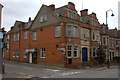
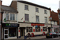
2
Faith Dimensions church, Stratford Road, Wolverton
Maybe not the ugliest building in Wolverton, but a strong contender.
Image: © Robert Eva
Taken: 8 May 2017
0.06 miles
5
The North Western, Stratford Road, Wolverton
Image: © Robert Eva
Taken: 8 May 2017
0.08 miles
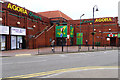
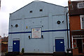
8
The Agora Centre from Radcliffe Street, Wolverton
Image: © Cameraman
Taken: 5 May 2011
0.15 miles
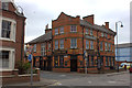
9
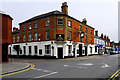
The Queen Victoria, Wolverton
The Queen Vic stands on the corner of Church Street and Radcliffe Street.
Image: © Cameraman
Taken: 5 May 2011
0.15 miles
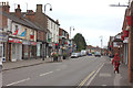
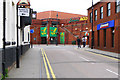
10
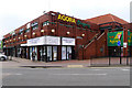
Agora Shopping Centre, Church Street, Wolverton
Image: © Cameraman
Taken: 5 May 2011
0.16 miles