IMAGES TAKEN NEAR TO
Dawson Road, MILTON KEYNES, MK1 1JW
Introduction
This page details the photographs taken nearby to Dawson Road, MK1 1JW by members of the Geograph project.
The Geograph project started in 2005 with the aim of publishing, organising and preserving representative images for every square kilometre of Great Britain, Ireland and the Isle of Man.

There are currently over 7.5m images from over14,400 individuals and you can help contribute to the project by visiting https://www.geograph.org.uk
Image Map (Loading...)


Getting Data...Please wait
Leaflet Map data © OpenStreetMap
Images are licensed for reuse under creativecommons.org/licenses/by-sa/2.0
Notes
- Clicking on the map will re-center to the selected point.
- The higher the marker number, the further away the image location is from the centre of the postcode.
Image Listing (3 Images Found)
Images are licensed for reuse under creativecommons.org/licenses/by-sa/2.0
Image
Details
Distance
1
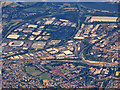
Milton Keynes
Passing over the Mount Farm suburb. The most obvious landmark is Stadium MK, home to MK Dons FC, on the left hand side of the photograph.
Image: © David Dixon
Taken: 16 Jul 2016
0.10 miles
3
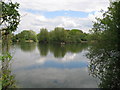
Milton Keynes: Mount Farm Park Lake
The lake is probably an old gravel pit working, and is certainly shown on the Ordnance Survey 6" to the mile maps of the area from 1952, thus pre-dating all the main development of Milton Keynes. It straddles this grid square and Image to the south. For another view, in that grid square, please see Image
Image: © Nigel Cox
Taken: 1 May 2010
0.22 miles