IMAGES TAKEN NEAR TO
Fabius Drive, MILTON KEYNES, MK11 4BW
Introduction
This page details the photographs taken nearby to Fabius Drive, MK11 4BW by members of the Geograph project.
The Geograph project started in 2005 with the aim of publishing, organising and preserving representative images for every square kilometre of Great Britain, Ireland and the Isle of Man.

There are currently over 7.5m images from over14,400 individuals and you can help contribute to the project by visiting https://www.geograph.org.uk
Image Map
Images are licensed for reuse under creativecommons.org/licenses/by-sa/2.0
Notes
- Clicking on the map will re-center to the selected point.
- The higher the marker number, the further away the image location is from the centre of the postcode.
Image Listing (7 Images Found)
Images are licensed for reuse under creativecommons.org/licenses/by-sa/2.0
Image
Details
Distance
1
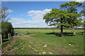
Path towards Milton Keynes and stile
Image: © Philip Jeffrey
Taken: 13 May 2012
0.15 miles
2
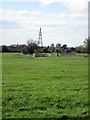
Wind pump on the path to Stony Stratford
Well, it's marked as a wind pump on the map but it seems to have lost its vanes.
Image: © Philip Jeffrey
Taken: 13 May 2012
0.18 miles

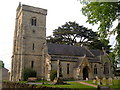
5

All Saints, Calverton, Bucks - East end
Image: © John Salmon
Taken: 18 Apr 2006
0.23 miles