IMAGES TAKEN NEAR TO
MK11 2WD
Introduction
This page details the photographs taken nearby to MK11 2WD by members of the Geograph project.
The Geograph project started in 2005 with the aim of publishing, organising and preserving representative images for every square kilometre of Great Britain, Ireland and the Isle of Man.

There are currently over 7.5m images from over14,400 individuals and you can help contribute to the project by visiting https://www.geograph.org.uk
Image Map
Images are licensed for reuse under creativecommons.org/licenses/by-sa/2.0
Notes
- Clicking on the map will re-center to the selected point.
- The higher the marker number, the further away the image location is from the centre of the postcode.
Image Listing (4 Images Found)
Images are licensed for reuse under creativecommons.org/licenses/by-sa/2.0
Image
Details
Distance
4
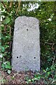
Old Milestone by the former A5, Watling Street, Bradwell Abbey
Stone post (plate lost) by the UC road (was A5), in parish of Bradwell Abbey (Milton Keynes District), Watling Street; Kiln Farm, 300m South East of Kiln Farm traffic island in vegetation by lamp post and pipeline sign, North-east side of road. Milton Keynes iron plate, erected by the Holyhead Road (Hockliffe Div) Turnpike Trust in the 19th century.
The last recorded inscription in 1958 read:-
(Stony Stratford 1)
(Fenny Stratford 5½)
Milestone Society National ID: BU_LH50.
Image: © Milestone Society
Taken: 22 Jun 2018
0.18 miles