IMAGES TAKEN NEAR TO
Shepherds, MILTON KEYNES, MK11 2BH
Introduction
This page details the photographs taken nearby to Shepherds, MK11 2BH by members of the Geograph project.
The Geograph project started in 2005 with the aim of publishing, organising and preserving representative images for every square kilometre of Great Britain, Ireland and the Isle of Man.

There are currently over 7.5m images from over14,400 individuals and you can help contribute to the project by visiting https://www.geograph.org.uk
Image Map
Images are licensed for reuse under creativecommons.org/licenses/by-sa/2.0
Notes
- Clicking on the map will re-center to the selected point.
- The higher the marker number, the further away the image location is from the centre of the postcode.
Image Listing (10 Images Found)
Images are licensed for reuse under creativecommons.org/licenses/by-sa/2.0
Image
Details
Distance

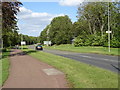
3
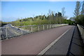
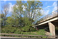
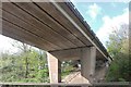
Footbridge out of Fuller's Slade over the A5
Image: © Philip Jeffrey
Taken: 13 Apr 2012
0.17 miles

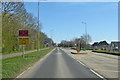
8

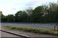
Milton Keynes : The A5
The A5 heading through Milton Keynes.
Image: © Lewis Clarke
Taken: 18 Mar 2019
0.21 miles
9
V4 Watling Street, Milton Keynes
The Roman Route, no longer the A5 through the town road grid.
Image: © Robin Webster
Taken: 22 Mar 2020
0.21 miles