IMAGES TAKEN NEAR TO
Woolrich Gardens, MILTON KEYNES, MK11 1JX
Introduction
This page details the photographs taken nearby to Woolrich Gardens, MK11 1JX by members of the Geograph project.
The Geograph project started in 2005 with the aim of publishing, organising and preserving representative images for every square kilometre of Great Britain, Ireland and the Isle of Man.

There are currently over 7.5m images from over14,400 individuals and you can help contribute to the project by visiting https://www.geograph.org.uk
Image Map (Loading...)


Getting Data...Please wait
Leaflet Map data © OpenStreetMap
Images are licensed for reuse under creativecommons.org/licenses/by-sa/2.0
Notes
- Clicking on the map will re-center to the selected point.
- The higher the marker number, the further away the image location is from the centre of the postcode.
Image Listing (40 Images Found)
Images are licensed for reuse under creativecommons.org/licenses/by-sa/2.0
Image
Details
Distance
1
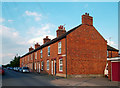
Coronation Road, Stony Stratford
Road not Street. Real houses with real people.
For some reason Coronation Road becomes Egmont Avenue at the end of the terrace. Both name plates are visible in this shot.
Image: © Des Blenkinsopp
Taken: 28 Jul 2011
0.03 miles
2
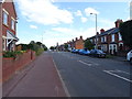
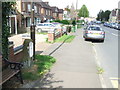
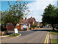
London Road, Stony Stratford
Towards Milton Keynes.
Image: © JThomas
Taken: 17 Aug 2019
0.05 miles
4
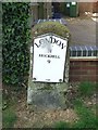
Old Milestone
Old milestone on what was the A.5 at Stony Stratford, Milton Keynes. For overall view see http://www.geograph.org.uk/photo/5381188
Image: © Keith Evans
Taken: 22 Apr 2017
0.06 miles
5
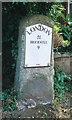
Old Milestone by the former A5 in Stony Stratford
Metal plate attached to stone post by the UC road (was A5), in parish of Wolverton (Milton Keynes District), London Road; by No. 46, opposite Citroen Garage, on cut grass between path and low garden wall, on South side of road. Milton Keynes iron plate (new), erected by the Holyhead Road (Hockliffe Division) turnpike trust in the 19th century.
Inscription reads:-
LONDON
51
BRICKHILL
9
1996
Milestone Society National ID: BU_LH51
Image: © A Rosevear
Taken: 19 Jul 2003
0.06 miles
6
Milestone
Old milestone on what was the A5 at Stony Stratford, Milton Keynes. For close up view see http://www.geograph.org.uk/photo/5381179
Image: © Keith Evans
Taken: 22 Apr 2017
0.07 miles
7
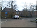
Old and New Telephone Exchanges, Stony Stratford
This photo, taken from the car park off Hawkins Close shows the old TE on the left and the new TE on the right of the photo. The old TE would appear to date from the late 1940s or early 1950s, whilst the new TE was built more recently. The postcode of this TE is MK11 1JL.
Image: © David Hillas
Taken: 16 Mar 2013
0.09 miles
8
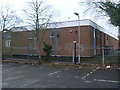
Telephone Exchange, Stony Stratford
Situated off London Road, this TE would appear to date from the 1980s replacing the former TE which can just be seen to the left of the photo. Besides Stony Stratford, this TE also serves Beachampton, Calverton, Cosgrove, Crownhill, Deanshanger, Fullers Slade, Great Holm, Old Stratford, Two Mile Ash and Wicken nearby. This TE has (01908) 26xxxx, 56xxxx and 57xxxx numbers, the (01908) referring to the Milton Keynes group of TEs.
Image: © David Hillas
Taken: 16 Mar 2013
0.09 miles
9
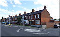
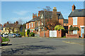
Blenheim Avenue, Stony Stratford
An area of suburban housing dating mainly from the 1920s and 30s.
Image: © Des Blenkinsopp
Taken: 28 Jul 2011
0.12 miles
10
Houses on Calverton Road, Stony Stratford
Image: © Robin Webster
Taken: 22 Mar 2020
0.12 miles