IMAGES TAKEN NEAR TO
Claremont Avenue, MILTON KEYNES, MK11 1HF
Introduction
This page details the photographs taken nearby to Claremont Avenue, MK11 1HF by members of the Geograph project.
The Geograph project started in 2005 with the aim of publishing, organising and preserving representative images for every square kilometre of Great Britain, Ireland and the Isle of Man.

There are currently over 7.5m images from over14,400 individuals and you can help contribute to the project by visiting https://www.geograph.org.uk
Image Map
Images are licensed for reuse under creativecommons.org/licenses/by-sa/2.0
Notes
- Clicking on the map will re-center to the selected point.
- The higher the marker number, the further away the image location is from the centre of the postcode.
Image Listing (9 Images Found)
Images are licensed for reuse under creativecommons.org/licenses/by-sa/2.0
Image
Details
Distance
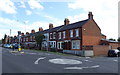
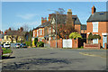
1
Blenheim Avenue, Stony Stratford
An area of suburban housing dating mainly from the 1920s and 30s.
Image: © Des Blenkinsopp
Taken: 28 Jul 2011
0.09 miles
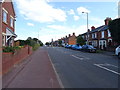
2
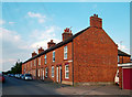
Coronation Road, Stony Stratford
Road not Street. Real houses with real people.
For some reason Coronation Road becomes Egmont Avenue at the end of the terrace. Both name plates are visible in this shot.
Image: © Des Blenkinsopp
Taken: 28 Jul 2011
0.17 miles
5
Houses on Calverton Road, Stony Stratford
Image: © Robin Webster
Taken: 22 Mar 2020
0.20 miles
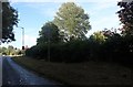
6
London Road, Stony Stratford
Towards Milton Keynes.
Image: © JThomas
Taken: 17 Aug 2019
0.21 miles
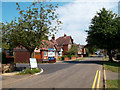
8
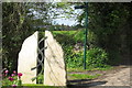
Path into Stony Stratford by the town sign
Image: © Philip Jeffrey
Taken: 13 May 2012
0.23 miles
9

Picnic area, Stony Stratford
Part of the picnic area on Calverton Road, Stony Stratford.
Image: © mick finn
Taken: 18 Oct 2008
0.25 miles