IMAGES TAKEN NEAR TO
Wolverton Road, MILTON KEYNES, MK11 1ED
Introduction
This page details the photographs taken nearby to Wolverton Road, MK11 1ED by members of the Geograph project.
The Geograph project started in 2005 with the aim of publishing, organising and preserving representative images for every square kilometre of Great Britain, Ireland and the Isle of Man.

There are currently over 7.5m images from over14,400 individuals and you can help contribute to the project by visiting https://www.geograph.org.uk
Image Map
Images are licensed for reuse under creativecommons.org/licenses/by-sa/2.0
Notes
- Clicking on the map will re-center to the selected point.
- The higher the marker number, the further away the image location is from the centre of the postcode.
Image Listing (64 Images Found)
Images are licensed for reuse under creativecommons.org/licenses/by-sa/2.0
Image
Details
Distance
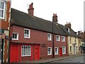
1
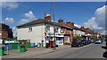
Local shop in Wolverton Road
A small convenience store in Wolverton Road, Stony Stratford.
Image: © Peter Mackenzie
Taken: 11 May 2019
0.03 miles
3
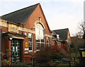
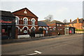
Russell Street School
There is an OS benchmark Image on the front on the school at the far end of the building
Image: © Roger Templeman
Taken: 23 Nov 2016
0.12 miles
4
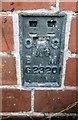
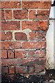
Benchmark on Russell Street School
Ordnance Survey flush bracket (serial identifier G2320) benchmark described on the Bench Mark Database at http://www.bench-marks.org.uk/bm161
Image: © Roger Templeman
Taken: 23 Nov 2016
0.12 miles
5
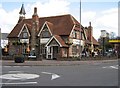
Edward Swinfen Harris
Former Church of England school built by Edward Swinfen Harris the architect between 1871-3, now The Plough Inn.
Image: © Malcolm Campbell
Taken: 8 Apr 2009
0.13 miles
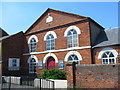
6
Independent Congregational Church, Wolverton Road
There is an OS benchmark Image on the brick wall pier right of the Chinese takeaway.
Image: © Roger Templeman
Taken: 23 Nov 2016
0.13 miles
7
Weathered benchmark on Congregational Church wall pier
Ordnance Survey cut mark benchmark described on the Bench Mark Database at http://www.bench-marks.org.uk/bm80528
Image: © Roger Templeman
Taken: 23 Nov 2016
0.14 miles
9
Former Rose and Crown Inn
Prince Edward V aged 12 who, accompanied by Sir Richard Grey, stopped here en route from Ludlow to Edward's proposed Coronation in London in June 1483.
They stayed overnight at what was then the Rose & Crown Inn and whilst there were captured by Richard, Duke of Gloucester.
http://www.mkheritage.co.uk/mkm/stonystratford/docs/tourframe.html
Image: © Malcolm Campbell
Taken: 12 Apr 2009
0.15 miles
10
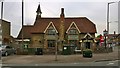
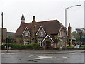
The Plough, Stony Stratford
The Plough, a public house in Stony Stratford in the Milton Keynes borough of Buckinghamshire, England.
Image: © Steven Haslington
Taken: 5 May 2014
0.15 miles