IMAGES TAKEN NEAR TO
Debbs Close, MILTON KEYNES, MK11 1DJ
Introduction
This page details the photographs taken nearby to Debbs Close, MK11 1DJ by members of the Geograph project.
The Geograph project started in 2005 with the aim of publishing, organising and preserving representative images for every square kilometre of Great Britain, Ireland and the Isle of Man.

There are currently over 7.5m images from over14,400 individuals and you can help contribute to the project by visiting https://www.geograph.org.uk
Image Map
Images are licensed for reuse under creativecommons.org/licenses/by-sa/2.0
Notes
- Clicking on the map will re-center to the selected point.
- The higher the marker number, the further away the image location is from the centre of the postcode.
Image Listing (11 Images Found)
Images are licensed for reuse under creativecommons.org/licenses/by-sa/2.0
Image
Details
Distance
1
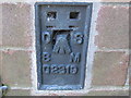
Ordnance Survey Flush Bracket G2319
This can be found on a house wall in Boundary Crescent.
For more detail see : http://www.bench-marks.org.uk/bm158
Image: © Peter Wood
Taken: 30 Nov 2012
0.13 miles
2
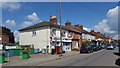
Local shop in Wolverton Road
A small convenience store in Wolverton Road, Stony Stratford.
Image: © Peter Mackenzie
Taken: 11 May 2019
0.16 miles
3
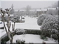
Midwinter in Breton
Breton from an upstairs window, February 2009
Image: © Steve Thompson
Taken: 6 Feb 2009
0.18 miles
5

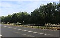
Milton Keynes : The A5
The A5 heading through Milton Keynes.
Image: © Lewis Clarke
Taken: 18 Mar 2019
0.21 miles
6
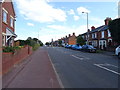
London Road, Stony Stratford
Towards Milton Keynes.
Image: © JThomas
Taken: 17 Aug 2019
0.24 miles
7
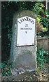
Old Milestone by the former A5 in Stony Stratford
Metal plate attached to stone post by the UC road (was A5), in parish of Wolverton (Milton Keynes District), London Road; by No. 46, opposite Citroen Garage, on cut grass between path and low garden wall, on South side of road. Milton Keynes iron plate (new), erected by the Holyhead Road (Hockliffe Division) turnpike trust in the 19th century.
Inscription reads:-
LONDON
51
BRICKHILL
9
1996
Milestone Society National ID: BU_LH51
Image: © A Rosevear
Taken: 19 Jul 2003
0.24 miles
8
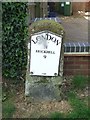
Old Milestone
Old milestone on what was the A.5 at Stony Stratford, Milton Keynes. For overall view see http://www.geograph.org.uk/photo/5381188
Image: © Keith Evans
Taken: 22 Apr 2017
0.24 miles
9
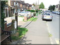
Milestone
Old milestone on what was the A5 at Stony Stratford, Milton Keynes. For close up view see http://www.geograph.org.uk/photo/5381179
Image: © Keith Evans
Taken: 22 Apr 2017
0.25 miles
10
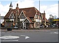
Edward Swinfen Harris
Former Church of England school built by Edward Swinfen Harris the architect between 1871-3, now The Plough Inn.
Image: © Malcolm Campbell
Taken: 8 Apr 2009
0.25 miles