IMAGES TAKEN NEAR TO
Mill Lane, MILTON KEYNES, MK11 1BQ
Introduction
This page details the photographs taken nearby to Mill Lane, MK11 1BQ by members of the Geograph project.
The Geograph project started in 2005 with the aim of publishing, organising and preserving representative images for every square kilometre of Great Britain, Ireland and the Isle of Man.

There are currently over 7.5m images from over14,400 individuals and you can help contribute to the project by visiting https://www.geograph.org.uk
Image Map
Images are licensed for reuse under creativecommons.org/licenses/by-sa/2.0
Notes
- Clicking on the map will re-center to the selected point.
- The higher the marker number, the further away the image location is from the centre of the postcode.
Image Listing (108 Images Found)
Images are licensed for reuse under creativecommons.org/licenses/by-sa/2.0
Image
Details
Distance
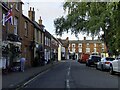
1
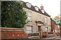
Stratford House
Grand Georgian house on Mill Lane
Image: © Richard Croft
Taken: 23 Aug 2007
0.06 miles
2
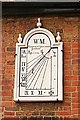
Sundial
The 18th century sundial on The Sundial House http://www.geograph.org.uk/photo/569821
Image: © Richard Croft
Taken: 23 Aug 2007
0.07 miles
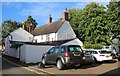
4
The Sundial House
At west end of Church Street with a sundial dated 1739
Image: © Richard Croft
Taken: 23 Aug 2007
0.08 miles
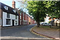
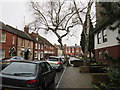
6
House on Church Street, Stony Stratford
Image: © David Howard
Taken: 27 Jun 2020
0.09 miles
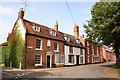
8
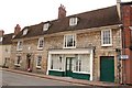
Former King's Head
One time coaching inn The King's Head with a datestone of 1790
Image: © Richard Croft
Taken: 23 Aug 2007
0.09 miles
9
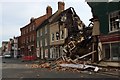
Aftermath of the fire on Stony Stratford High Street
Image: © Philip Jeffrey
Taken: 6 May 2016
0.10 miles
10
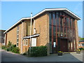
St Mary Magdalene Roman Catholic Church
Image: © Simon Atkin
Taken: 8 May 2008
0.10 miles