IMAGES TAKEN NEAR TO
Church Street, MILTON KEYNES, MK11 1BD
Introduction
This page details the photographs taken nearby to Church Street, MK11 1BD by members of the Geograph project.
The Geograph project started in 2005 with the aim of publishing, organising and preserving representative images for every square kilometre of Great Britain, Ireland and the Isle of Man.

There are currently over 7.5m images from over14,400 individuals and you can help contribute to the project by visiting https://www.geograph.org.uk
Image Map (Loading...)


Getting Data...Please wait
Leaflet Map data © OpenStreetMap
Images are licensed for reuse under creativecommons.org/licenses/by-sa/2.0
Notes
- Clicking on the map will re-center to the selected point.
- The higher the marker number, the further away the image location is from the centre of the postcode.
Image Listing (116 Images Found)
Images are licensed for reuse under creativecommons.org/licenses/by-sa/2.0
Image
Details
Distance
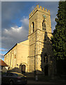
3
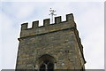
Vane at top of the tower of St Mary and St Giles Church
The ordnance Survey used the vane, mounted on top of a flagstaff, for triangulation, http://trigpointing.uk/trig/19987 , but now birds find it useful for resting
Image: © Roger Templeman
Taken: 23 Nov 2016
0.02 miles
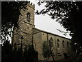
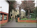
5
St Mary & St Giles Church, Stony Stratford
Grade 2 listed church dating from 1776. https://en.wikipedia.org/wiki/St_Mary_%26_St_Giles_Church,_Stony_Stratford
Image: © Paul Harrop
Taken: 25 Sep 2015
0.03 miles
6
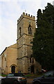
Church of St Mary and St Giles
The tower centre, flagstaff and vane are components of an Ordnance Survey intersected station trig point, http://trigpointing.uk/trig/19987
Image: © Roger Templeman
Taken: 23 Nov 2016
0.03 miles
8
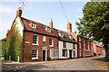
The Sundial House
At west end of Church Street with a sundial dated 1739
Image: © Richard Croft
Taken: 23 Aug 2007
0.03 miles
9
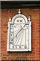
Sundial
The 18th century sundial on The Sundial House http://www.geograph.org.uk/photo/569821
Image: © Richard Croft
Taken: 23 Aug 2007
0.03 miles
10
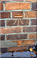
Benchmark on #59 High Street
Ordnance Survey cut mark benchmark described on the Bench Mark Database at http://www.bench-marks.org.uk/bm80575
Image: © Roger Templeman
Taken: 23 Nov 2016
0.03 miles