IMAGES TAKEN NEAR TO
The Newmanry, MILTON KEYNES, MK10 9TT
Introduction
This page details the photographs taken nearby to The Newmanry, MK10 9TT by members of the Geograph project.
The Geograph project started in 2005 with the aim of publishing, organising and preserving representative images for every square kilometre of Great Britain, Ireland and the Isle of Man.

There are currently over 7.5m images from over14,400 individuals and you can help contribute to the project by visiting https://www.geograph.org.uk
Image Map
Images are licensed for reuse under creativecommons.org/licenses/by-sa/2.0
Notes
- Clicking on the map will re-center to the selected point.
- The higher the marker number, the further away the image location is from the centre of the postcode.
Image Listing (6 Images Found)
Images are licensed for reuse under creativecommons.org/licenses/by-sa/2.0
Image
Details
Distance
1
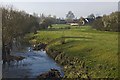
River Ouzel at Great Woolstone
View from the footbridge over the river, with the former Holy Trinity Church, now Rosebery Music room in the distance to the right.
Image: © Paul Harrop
Taken: 25 Mar 2012
0.19 miles
2
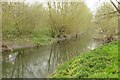
The River Ouzel in Milton Keynes
The River Ouzel flows through the Ouzel Valley Park.
Image: © Steve Daniels
Taken: 3 Apr 2014
0.19 miles
3
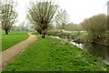
Path by the River Ouzel
The River Ouzel flows through the Ouzel Valley Park.
Image: © Steve Daniels
Taken: 3 Apr 2014
0.19 miles
4
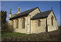
Former church, Milton Keynes
The former Holy Trinity Church, on Newport Road, Great Woolstone, now Rosebery Music room. The Grade 2 listed former parish church is now a rehearsal room and dates from 1839.
Image: © Paul Harrop
Taken: 25 Mar 2012
0.22 miles
5
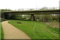
The path runs under Chaffron Way
The path runs north through the Ouzel Valley Park.
Image: © Steve Daniels
Taken: 3 Apr 2014
0.23 miles
6
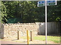
Water Pumping Station
Maintenance station for a water pump in old village of Woolstone.
Image: © Mr Biz
Taken: 25 Jul 2006
0.25 miles